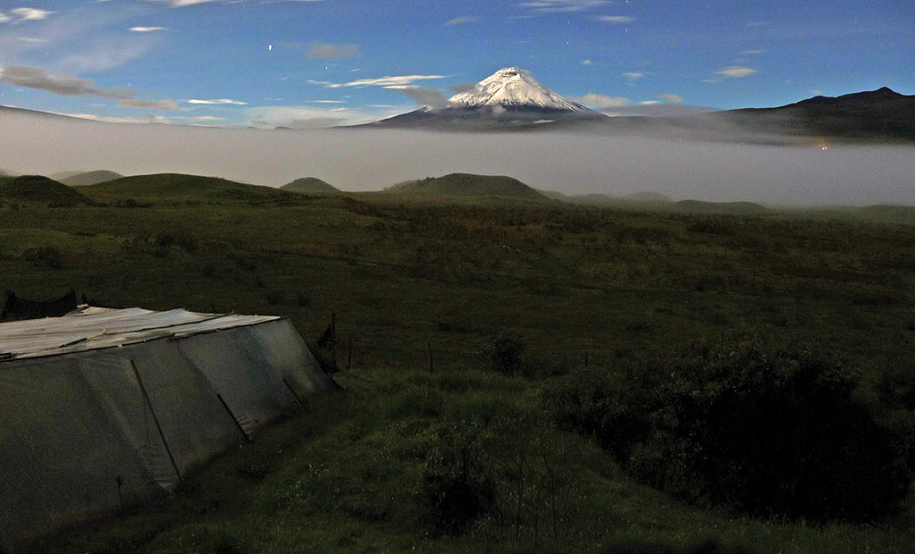
Visiting Ecuador’s Cotopaxi National Park
Ecuador’s top mainland national park is second only to the Galápagos in the annual number of visitors, and it’s easy to see why. Less than two hours south of Quito, 33,400 stunning hectares enclose one of the most beautiful volcanoes in the Americas, along with two other peaks higher than 4,700 meters, and extensive verdant páramo where llamas graze and wild horses gallop. Tours of the park vary from gentle hikes and cycle rides to scaling the volcano itself, considered one of Ecuador’s best climbs.
Flora and Fauna
The lower elevations on the edges of the park contain wet montane forests at about 3,600–3,800 meters, but the largest section is covered by sub-Andean páramo at 4,000–4,500 meters. This is where you’ll find most of the park’s animals: deer, rabbits, and the endemic marsupial mouse. More elusive are pumas and endangered spectacled bears. There are more than 90 species of birds, including carunculated caracaras, shrike-tyrants, ground-tyrants, great thrushes, rufous-naped brush-finches, Andean gulls, noble snipes, and brown-backed chat-tyrants (related to flycatchers). If you’re lucky, you may spot an Andean condor soaring overhead.
Shrubby blueberries and lupines bloom next to Indian paintbrush and members of the daisy family, while the occasional terrestrial bromeliad is pollinated by hummingbirds. You might spot the urcu rosa, a small blue mountain rose, hidden among the tough ugsha grass. Above 4,500 meters to the snowline at 4,700 meters, plunging temperatures keep the mossy tussocks of the Andean tundra relatively empty.
Access
The two main entrances to the park are south of Machachi along the Panamericana. The first turnoff, 16 kilometers south of Machachi, is also the entrance to El Boliche National Recreation Area. It passes the CLIRSEN satellite tracking station before forking three ways. Take the right fork and follow the train tracks for 500 meters. From here, it’s six kilometers downhill through a forest to a campsite with fireplaces and simple cabins.
The second entrance turnoff is nine kilometers farther south; this is the most popular access point, making it easier to hitch a ride into the park, especially on weekends (although the road washes out occasionally in the rainy season). It joins with the northern access road at the park boundary, where you pay the entrance fee ($10 pp) at the gate, which is open daily.
The road through the park curves in a semicircle north around Volcán Cotopaxi. As it heads northeast, it passes the administrative center at Campamiento Mariscal Sucre, 10 kilometers from the gate. A small museum here has an exhibition on the geology, history, flora, and fauna of the park. Shortly beyond the museum, which is usually the first stop on a guided tour, there’s a path leading to Laguna Limpiopungo, a shallow lake at 3,800 meters elevation whose reeds provide a habitat for several species of birds.
On a small hill 15 kilometers beyond the lake are the oval ruins of El Salitre, formerly an Inca pucara (fortress), abandoned soon after the arrival of the Spanish.
A trail leads around the lake to the northwest for access to Rumiñahui. Shortly beyond that trail, another jeep track heads nine kilometers south to the Jose Rivas Refuge, the best base for climbing expeditions. Note that the hike to the refuge is tougher than you may expect if you’re not fully acclimated (which you won’t be if you’re coming from Quito).
Many of the day tours include mountain biking in the park, which is a great way to cover more distance. You are usually taken up to a refuge for a dramatic downhill ride, which gets the adrenaline pumping without tiring you out.
Climbing Volcán Cotopaxi
Cotopaxi may not be Ecuador’s highest mountain but it’s certainly the most photogenic. This perfectly symmetrical cone has been captivating climbers and photographers for years, and many of the local indigenous people, who named it “the neck of the moon” in Kichwa, still worship the volcano as god of the valley. However, Cotopaxi’s beauty masks the beast that lies within. While it is probably not the world’s highest active volcano (that title most likely belongs to Llullaillaco on the Chilean-Argentine border, which erupted in 1877), there’s no denying Cotopaxi’s destructive ability.
Cotopaxi’s first recorded eruption disrupted a battle between the Spanish and the Inca in 1534, and since then it has erupted on over 10 occasions, destroying Latacunga several times. Eruptions in 1742, 1768, and 1877 were the worst, killing hundreds of people. Cotopaxi registered minor eruptions in 1906 and as recently as the 1940s, but at present activity is limited to steam rising from the crater, only visible to climbers who reach the summit.
A German and Colombian climbing team first set foot on Cotopaxi’s glacier-covered peak in 1872, followed 10 years later by Edward Whymper, who opened the northern route still in use today. The climb is not technically difficult, as the many climbers who scale the ice-covered slopes regularly will attest. Crevasses are usually large and obvious, making the climb mostly an uphill slog. However, less than half of those who attempt the summit actually reach it. You need to be in very good physical condition, be fully acclimated, and have an experienced guide and a certain amount of luck with the conditions. Technical equipment is necessary: ice axes, crampons, ropes, and marker wands.
Although Cotopaxi can be climbed year-round—it sees more clear days than almost any other peak in the Ecuadorian Andes—the best months are December–January. August–September are also good but windy. February–April can be clear and dry as well, while August–December are usually windy and cloudy.
As with any peak over 5,000 meters, acclimation is essential. If you’ve been staying in Quito at 2,800 meters, this is unlikely to be sufficient acclimation to scale Cotopaxi on a two-day excursion (although you may be lucky). Ideally you should trek and sleep at around 4,000 meters for a couple of days, or even better, do a practice climb of a smaller peak such as Iliniza Norte or Rumiñahui before attempting Cotopaxi.
The road to the refuge heads south from the main park road for nine kilometers to the parking area at 4,600 meters. A half-hour hike up a steep, sandy trail brings you to the José Ribas refuge (4,800 meters), which was built in 1971 by the San Gabriel Climbing Club. The two-story shelter is fully equipped with bunk beds ($20 pp), cooking facilities, running water, and snacks and water for sale as well as lockable storage space for gear. A night’s stay is usually included in the price of a guided tour. To reach the summit, catch a few hours of sleep before waking around midnight to start climbing. It takes 6–10 hours from the refuge, and the route contains smoking fumaroles reeking of sulfur. The views over the other volcanoes on the “avenue” are spectacular, and you should be able to see the lights of Quito in the distance. The descent takes 3–6 hours.
Climbing Volcán Rumiñahui
This peak, 13 kilometers northwest of Cotopaxi, was named after Atahualpa’s bravest general, who famously hid the huge Inca ransom after Atahualpa’s death and refused to give up its whereabouts when tortured by the Spanish. The history of its name is luckily the most violent aspect of Rumiñahui (4,712 meters), which is heavily eroded and officially dormant but most probably extinct. There are actually three peaks, and the volcano offers a relatively straightforward climb, combining an uphill hike with a bit of scrambling, but because the quality of rock can be poor, a rope and climbing protection are recommended for the more exposed stretches.
The east side of Rumiñahui is reached through Cotopaxi Park along tracks that skirt Laguna Limpiopungo to the north or south. A path toward the central peak is clearly visible along a well-defined ridge. From the lake to the base is about a two-hour hike, and camping along the way is possible. The south peak involves some moderate technical rock climbing (class 5.5). The IGM Machachi and Sincholagua 1:50,000 maps cover this area.
El Boliche National Recreation Area
Ecuador’s smallest nationally protected area at 1,077 hectares, El Boliche National Recreation Area hugs the southwestern side of Cotopaxi National Park. Boliche is perfect for visitors who are more interested in weekend family picnics and mild hikes than mountaineering, with cabins, camping spots, sports fields, and self-guided trails.
The habitat here at 3,500 meters is dominated by pine trees planted through reforestation programs in the 1960s and 1970s. The pines have actually disrupted the local ecosystem and caused problems for Quito’s water supply, which draws heavily on this area. However, the thickly forested trails are very beautiful and make a refreshing change from the grasslands that dominate the rest of the region. Visitors may catch sight of deer, rabbits, and the occasional wolf. Llamas and guarizos (offspring of llamas and alpacas) have been released in the park and are reproducing well.
The entrance to El Boliche is the same as the northern turnoff for Cotopaxi off the Panamericana—16 kilometers south of Machachi. Admission ($10 pp) is combined with the entry to Cotopaxi. The train service from Quito to Latacunga passes through Thursday–Sunday.