The Terrain and Geography of Guatemala
Guatemala is the third-largest country in Central America. It occupies 42,042 square miles, making it about the size of Tennessee. The country shares borders with Mexico, Belize, Honduras, and El Salvador. Within Guatemala’s relatively small area are 14 distinct ecosystems found at elevations varying from sea level to higher than 4,200 meters (14,000 feet).
Many people think of Guatemala as a sweltering tropical country, which is only partially true. While it does feature warm tropical coastal environments and hot lowland jungles, a rugged spine of mountains and volcanoes runs through the country’s center. In the tropics, elevation mostly determines climate and this is certainly the case in Guatemala. Temperatures drop dramatically the higher you go in elevation and precipitation varies greatly depending on what side of a mountain chain you’re on. All of this translates into a dizzying array of landscapes, making Guatemala a delight to explore.
The country divides rather neatly into various geographical zones. The volcanic highlands run through the country’s center going west to east from Mexico to El Salvador. Elevation tends to get lower closer to the Salvadoran border. The eastern area of Las Verapaces is largely mountainous but also largely composed of limestone. A curious feature of this area, found in its northern limits, is the presence of small, forested limestone hills much like those found in parts of China. East from Guatemala City toward Honduras, the terrain is largely dominated by semiarid flatlands covered in cactus.
Closer to the Caribbean coast in the department of Izabal, the terrain once again becomes lush and largely filled with banana plantations. A small sliver of Caribbean coastline runs between the Honduran border and Belize but features white-sand beaches, swamplands, and some impressive tropical rainforests. Small mountains are interspersed throughout parts of the Caribbean coastal region.
Running roughly parallel to the highlands, to the south, are Pacific Coast flatlands. This is a rich agricultural area once covered in tropical forest but now home to vast sugarcane and coffee plantations, the latter being on the slopes of the highland zones as they descend into the coastal plain. The Pacific Coast is also home to wetlands, mangrove swamps, and beaches of curiously dark color because of their proximity to the country’s volcanic chain.
The northern third of Guatemala is a vast Ohio-size limestone flatland known as Petén. Once covered entirely in tropical forests, it has increasingly become deforested in its southern parts with only the northern third retaining large unbroken swaths of forest.
Here is a brief discussion of some of Guatemala’s outstanding geographic features and why they might be of interest to the visitor.
Newsletter Signup
By clicking ‘Sign Up,’ I acknowledge that I have read and agree to Hachette Book Group’s Privacy Policy and Terms of Use
Additional Information on Guatemala’s Terrain
Mountains
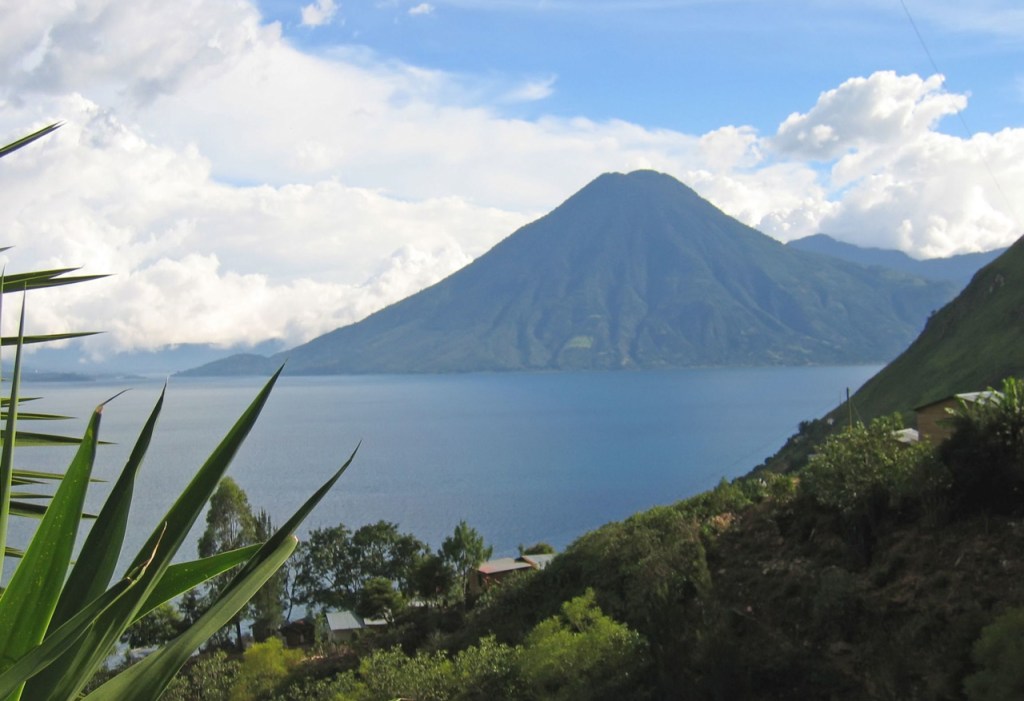
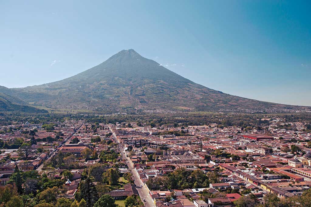
The highest of Guatemala’s mountains are actually volcanic peaks. There are 33 of them in total with a handful now active. Volcán Tajumulco, at 4,220 meters (13,845 feet), is the highest point in all of Central America, followed closely by nearby Volcán Tacaná, at 4,110 meters (13,484 feet). The most frequently climbed volcanoes include the active Pacaya, in Pacaya Volcano National Park near Guatemala City, the three volcanoes on the shores of Lake Atitlán, Agua, and Acatenango near Antigua. Some volcanoes, such as Chicabal and Ipala, feature turquoise lagoons, which fill their craters. Other active volcanoes include Fuego and Santiaguito.
Among the nonvolcanic mountains, the Sierra de los Cuchumatanes, near the border with Mexico, is Guatemala’s, and Central America’s, highest mountain chain. It stands 3,837 meters (12,588 feet) at its highest point. Its smooth, rounded peaks attest to years of erosion from being glaciated thousands of years ago. Other noteworthy mountain chains include the Sierra de Las Minas, in the eastern part of the country. Protected as a private forest reserve, Sierra de Las Minas Biosphere Reserve still contains large stands of virgin cloud forest.
Farther east near the Caribbean Coast are the Cerro San Gil and Montañas del Mico, which are still covered in dense tropical rainforest. Petén has relatively few mountains, but the foothills of the Maya Mountains of neighboring Belize run into the department’s southeastern corner with an elevation of over 1000 meters (3,300 feet) at Petén’s highest point. Petén’s other noteworthy mountain range is the remote and mostly forested Sierra del Lacandón, at the far western edge of the department bordering Mexico and exceeding 600 meters (2,000 feet) at its highest point.
Guatemala’s mountain scenery comes largely as a product of its geographic location at the intersection of the North American, Cocos, and Caribbean plates, making it one of the most seismically and volcanically active places in the world. Indeed, Guatemala is no stranger to earthquakes. Among the many fault lines running through the country are the parallel Chixoy-Polochic and Motagua faults.
The latter is responsible for the most recent major earthquake to rock Guatemala, a magnitude-7.5 whopper in February 1976 killing thousands and wiping entire villages off the face of the map. A series of massive earthquakes in 1776 resulted in the relocation of the Guatemalan capital from the Panchoy Valley (Antigua Guatemala) to the Valley of the Hermitage, where it remains today, better known as Guatemala City.
Rivers
Guatemala has several rivers worthy of mention. The greatest of these is the Río Usumacinta, which is formed by the confluence of the Chixoy and Pasión Rivers, making it Central America’s most voluminous river. Guatemalan author Virgilio Rodríguez Macal, in his novel Guayacán, calls it the “father and lord of the Central American rivers.”
The Usumacinta forms much of Guatemala’s border with Mexico and continues its northwesterly flow all the way to the Gulf of Mexico. On the Guatemalan side, the Usumacinta borders the relatively untouched Sierra del Lacandón National Park, which harbors dense tropical rainforests. Rafting trips once made their way down the Usumacinta, visiting Yaxchilán (Mexico) and the Guatemalan site of Piedras Negras, but an increase in violent armed robberies has meant their indefinite suspension.
The Usumacinta is indeed a wild frontier and is an active waterway for drug smuggling, contraband logging, and boats carrying illegal immigrants on their journey north. An on-again, off-again Mexican dam project has been vehemently opposed by environmentalists and, until 1996, Guatemalan rebels camped out in the jungle. The project would reportedly flood Piedras Negras, Yaxchilán, and several smaller sites along the Usumacinta. The project appears to have been called off, for the time being.
The Pasión, an Usumacinta tributary, meanders through southern Petén. Much like the larger Usumacinta, its watershed was extremely important in Mayan times. Several Mayan sites lie near the river. In the arid southeastern part of the country, the Río Motagua connects the highlands to the Caribbean Sea and forms a dry river valley of agricultural importance since Mayan times.
Other notable rivers include the Río San Pedro, also in Petén; the Verapaces-area Río Cahabón, which has excellent white-water runs year-round; and the Río Dulce, a lazy tropical river connecting Lake Izabal to the Caribbean.
Lakes and Lagoons
Guatemala has several lakes noteworthy for their size, recreational opportunities, and sheer natural beauty. Foremost among these is highland Lake Atitlán, called “the most beautiful lake in the world” by author Aldous Huxley during his travels through the region. The lake’s spectacular mountain scenery is punctuated by the sentinel presence of three towering volcanoes along its southern shores.
Lake Amatitlán has been a weekend getaway for city dwellers since time immemorial but industrial pollution has spoiled the once-clear waters. Still, Guatemalans have taken on the ominous task of rescuing its waters with foreign help and the lake may soon be safe again for swimming. An aerial tram operating on surrounding hillsides has recently reopened the area to visitors, making a side trip to this tranquil spot increasingly alluring for wonderful views of the rugged mountain terrain.
Lake Izabal, is a tropical lake connected to the Caribbean by the Río Dulce. Bocas del Polochic Wildlife Refuge, on Izabal’s southwestern shore, is becoming increasingly popular as a bird-watcher’s paradise.
Lake Petén Itzá is also a tropical flatland lake with the added bonus of tropical forests, crystal-clear waters, and a variety of accommodations from which to enjoy all of these. As much of Petén is limestone, the lake’s waters have a distinct turquoise color near the lakeshores and from the air look very much like those of the Mexican Caribbean.
Yaxhá ruins. The lagoon, and its aggressive crocodiles, was made famous by the Survivor Guatemala television series filmed here in the summer of 2005.
There are many beautiful lagoons in the Guatemalan highlands. Some, atop volcanoes such as Ipala and Chicabal, are believed by the Mayans to harbor mystical powers and are the site of rituals. Laguna Lachuá National Park has a beautiful, almost perfectly round lagoon in the Ixcán jungle region just north of the highlands. The surrounding rainforest has been preserved, but unfortunately it is an ecological island, a green square in a surrounding ocean of deforestation.
The Coasts
Guatemala has a significant amount of coastline along the Pacific Coast, though there are few beaches to speak of. Still, there are a few places with surf-worthy waves and Pacific Coast beaches are exotic because of their dark sands, which are due to the proximity of active volcanoes. Among the best places to hit the beach are Monterrico and Las Lisas.
Guatemala is gaining international fame among anglers for the quality of its deep-sea fishing. In fact, Guatemala is known as the sailfish capital of the world.
On the Caribbean side, there are a few pleasant white-sand beaches on the remote peninsula of Punta de Manabique Wildlife Refuge as well as closer to the towns of Puerto Barrios and Lívingston. There is excellent scuba diving in the outlying Belize cayes and around Punta de Manabique.

Newsletter Signup
By clicking ‘Sign Up,’ I acknowledge that I have read and agree to Hachette Book Group’s Privacy Policy and Terms of Use