Parque Nacional Torres del Paine Hiking and Climbing
Some of the Andes’s youngest peaks, the Torres del Paine are among the range’s most emblematic sights. Some 10 million years ago, a magma intrusion failed to reach the earth’s surface, cooling underground into resistant granite. In the interim, water, ice, and snow have eroded softer terrain to liberate the spires as one of the world’s most dramatic landscapes.
So strong a draw are the Torres that some visitors pressed for time settle for day tours that allow only a few hours in the park. Others walk to their base from Hostería Las Torres, a relatively easy day hike where it’s hard to avoid the crowds. A longer and more tiring alternative, up the steep Río Bader canyon, provides a different perspective and the Andean solitude that many hikers seek.

Cuernos del Paine
Many park visitors misidentify the Cuernos del Paine (Horns of Paine) as the Torres. Located almost immediately south of the Torres proper, the saw-toothed Cuernos retain a cap of darker but softer metamorphic rock atop a broader granitic batholith that, like the Torres, never reached the surface before cooling. It’s the contrast between the two that gives the Cuernos their striking aspect.
As with the Torres, day-trippers can admire the Cuernos from the park highway. The best views, though, come from the “W” trail along the north shore of Lago Nordenskjöld, between Hostería Las Torres and Lago Pehoé.
Hiking
Paine Circuit
Nearly three decades ago, under a military dictatorship, Chile attracted few foreign visitors, and hiking Torres del Paine was a solitary experience. On a 10-day trek over the now-famous Paine Circuit, this author met only three other hikers. Parts of the route were easy to follow, while others were barely boot-wide tracks on steep slopes, or involved scrambling over granite boulders and fording waist-deep glacial meltwater.
Today, much has changed. At peak season, hikers are so numerous that the route can approach gridlock (hyperbole intentional). Rudimentary and not-so-rudimentary bridges make water crossings easier. In addition to the lean-tos that once sheltered shepherds, there are enough comfortable refugios (shelters) and organized campgrounds that it’s theoretically possible to complete most of the circuit without a tent or even a sleeping bag. Still, hikers must remember that this is rugged country with unpredictable weather and come well-prepared.
Most hikers tackle the circuit counterclockwise from Guardería Laguna Amarga, where buses from Puerto Natales stop for passengers to pay the park admission fee. An alternative is to continue to Pudeto and take a passenger launch to Refugio Pehoé, or else to the park’s Administración (involving a longer and less interesting approach). Both of these mean doing the trek clockwise.
A trail along Lago Nordenskjöld’s north shore provides access to the Torres’s south side, offering easier access up the Río Ascencio and Valle del Francés on the shorter “W” route to Lago Pehoé. The circuit follows the river’s west bank south to Laguna Amarga. (A Laguna Azul, exit or entrance is feasible as well by crossing the Río Paine by a cable raft at the river’s Lago Dickson outlet, with help from the staff at Refugio Dickson.)
The full circuit takes at least a week to complete. Before beginning, hikers must register with park rangers. Camping is permitted only at designated sites, a few of which are free. Purchase supplies in Puerto Natales, as only limited goods are available within the park, at premium prices.

The “W” Variant
From Guardería Laguna Amarga, a narrow undulating road crosses the Río Paine on a narrow suspension bridge to the grounds of Estancia Cerro Paine, at the foot of 2,640-meter Monte Almirante Nieto. The estancia operates a hotel, refugios (shelters), and campgrounds, and the staff also shuttles hikers back and forth from Laguna Amarga (US$5.50 pp).
From Estancia Cerro Paine, a northbound trail parallels the route from Guardería Laguna Amarga, eventually meeting it just south of Campamento Serón. The estancia is more notable, though, as the starting point for the “W” route to Lago Pehoé, a scenic and challenging option for hikers lacking time for the full circuit. On the western edge of the grounds, the footbridge crosses the Río Ascencio to a junction where a northbound lateral trail climbs the river canyon to Campamento Torres, where a short but steep trail ascends to a nameless glacial tarn at the foot of the Torres proper. Weather permitting, this is a recommended day hike from the estancia, though many people prefer to camp or spend the night at the refugio.
From the junction, the main trail follows Lago Nordenskjöld’s north shore, past another refugio and campground, to the free Campamento Italiano at the base of the Río del Francés valley. While the main trail continues west toward Lago Pehoé, another northbound lateral trail climbs steeply up the valley, between the striking metamorphic Cuernos del Paine to the east and the 3,050-meter granite summit of Paine Grande to the west, to the free Campamento Británico.
Hikers in search of peace and quiet can make a strenuous detour up the Valle Bader, a steep rugged river valley that’s home to a climber’s camp at the Cuernos’ base. The route is mostly unmarked, but experienced cross-country walkers can handle it.
Other Trails
After heavy runoff destroyed the once-sturdy bridge at Lago Paine’s outlet in the early 1980s, the Río Paine’s north shore became isolated from the rest of the park. A good road, though, still leads from Guardería Laguna Amarga to Laguna Azul’s east end, which has a campground and cabañas, as well as the Sendero Lago Paine, a four-hour walk to the lake and a simple refugio (shelter). A trekkers’ alternative is the Sendero Desembocadura, which leads north from Guardería Laguna Amarga through open country to Laguna Azul’s west end and continues to Lago Paine, but this takes about eight hours. From the north shore of Lago Paine, the Sendero Lago Dickson (5.5 hours) leads to the Dickson Glacier.
Several easy day hikes are possible near Guardería Lago Pehoé, directly on the road from Laguna Amarga to the visitors center. The short Sendero Salto Grande trail leads to the thunderous waterfall, at Lago Sarmiento’s outlet, that was the circuit’s starting point until unprecedented runoff swept away the iron bridge to Península Pehoé in 1986. From Salto Grande, the Sendero Mirador Nordenskjöld is a slightly longer but still easy walk to a lakeshore vista point, directly opposite the stunning Cuernos del Paine.
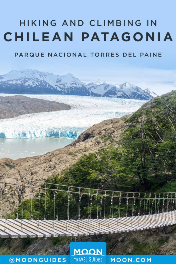
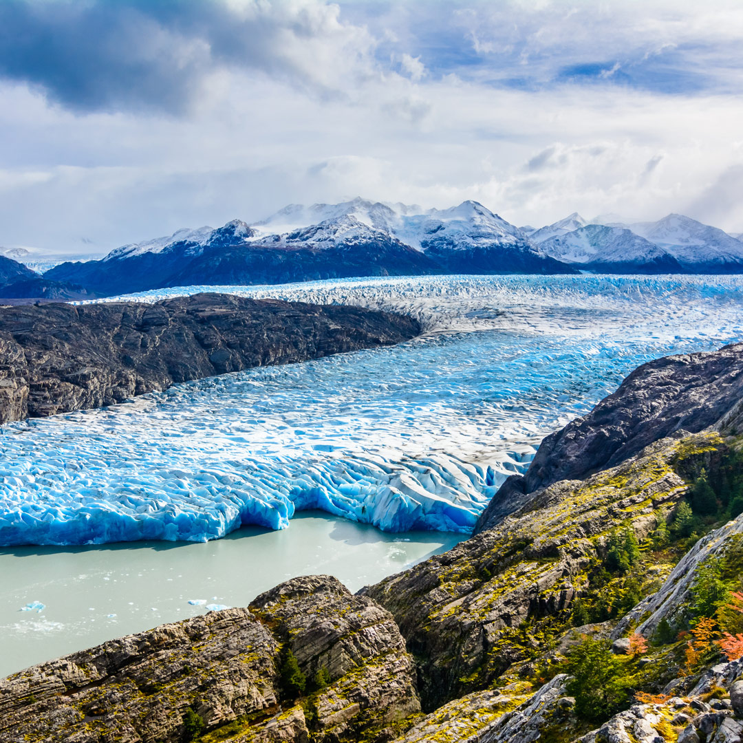
From Guardería Lago Grey, 18 kilometers northwest of the visitors center by road, a short footpath leads to a sandy beach on Lago Grey’s south shore, where steady westerlies often beach icebergs from Glaciar Grey. The longer and less visited Sendero Lago Pingo ascends the Río Pingo Valley to its namesake lake (5.5-6 hours). A basic refugio and two free campgrounds are along the route.
Climbing
Though popular, hiking is not the only recreational option. Despite similar terrain, Paine attracts fewer climbers than Argentina’s neighboring Parque Nacional Los Glaciares, perhaps because fees for climbing permits have been high here. At present, permits are free of charge; before being granted permission, climbers must present Conaf with climbing résumés, emergency contacts, and authorization from their consulate.
When climbing in sensitive border areas (meaning most of Andean Chile), climbers must also have permission from the Dirección de Fronteras y Límites (Difrol) in Santiago. It’s possible to do this through a Chilean consulate overseas or at Difrol’s Santiago offices or, preferably, online. If you arrive in Puerto Natales without permission, it’s possible to request it through the Gobernación Provincial (tel. 061/241-1423), the regional government offices on the south side of Plaza Arturo Prat. The turnaround time is 48 hours.
While climbing and mountaineering activities may be undertaken independently, local concessionaires can provide training and lead groups or individuals with less experience on snow and ice. Big Foot Adventure Patagonia (tel. 061/241-4611 in Natales) has a Refugio Grey base camp, where it leads half-day traverses of Glaciar Grey’s west side (US$140) and 2.5-hour kayak excursions (US$90). It also operates guided three-day, two-night descents of the Río Serrano (US$795-1,090 pp, depending on group size). Except for weatherproof clothing, the company provides all equipment.
Related Travel Guide
Pin For Later