Exploring New Mexico’s Bandelier National Monument
One of New Mexico’s most atmospheric ancient sites, Bandelier National Monument comprises 23,000 acres of wilderness, including the remarkable Frijoles Canyon, lined on either side with cave “apartments,” while the remnants of a massive settlement from the 16th century occupy the valley floor.
The place gets so busy in summer that from Memorial Day through October, the park is accessible only by shuttle bus from the visitors center in White Rock. The best way to avoid crowds is to arrive early on a weekday, if possible. Another approach is to join a torch-lit, silent night walk into Frijoles Canyon; they’re typically on Friday nights, but call the visitors center or check online for the schedule.

In the park, another visitors center has a museum and the usual array of maps and guides. If you’re interested in wildflowers, pick up a Falls Trail guide (even though this trail is unfortunately closed due to floods in 2013), as it has good illustrations of what grows in the area. Rangers run free guided walks around the main loop a few times a day, or you can pick up the trail guide for $1.
Main Loop Trail and Alcove House Trail
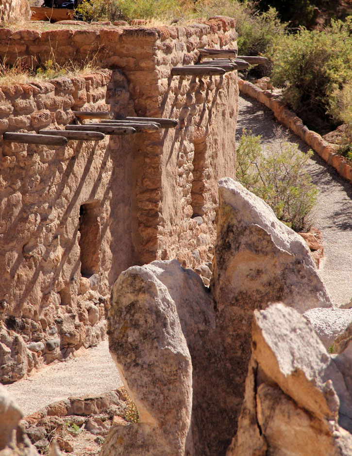
A paved walkway leads out the back of the visitors center into Frijoles Canyon, passing the ruins of the major settlements—or at least the ones that have been thoroughly excavated. You first reach Tyuonyi (chew-ON-yee), a circle of buildings that was settled for about 200 years, beginning in the 1300s. Built of bricks cut from tuff (the volcanic rock that makes up most of the area) and adobe plaster, some of the 250 rooms at one time stood several stories tall.
The trail then goes up next to the cliffs, dotted with small caves dug out of the soft stone, and to Long House, the remnants of a strip of condo-style buildings tucked into the rock wall. Paintings and carvings decorate the cliff face above. If you’re here near sunset, keep an eye on the bat cave near the end of the strip, home to thousands of the animals.
Continue another half mile to the Alcove House, accessible by 140 feet of ladders. It’s well worth the climb up, if you can handle heights—though at the time of research, floods had required rerouting of the trail, making it a bit trickier. Also, the kiva at the center of the cliff house was closed for restoration.
Frey Trail
The 1.5-mile Frey Trail used to be the main access route to Frijoles Canyon, before the access road was built by the Civilian Conservation Corps in the 1930s. Descending from Juniper Campground (just off Highway 4 northwest of the park access road), it’s a nice approach to the area, with great views over Tyuonyi, and a general sense of what it must have been like to “discover” the canyon. The trail has no shade, however, so it’s best hiked early in the day. The shuttle bus can drop you at the trailhead, so you can hike down, then ride back to the depot.
Tsankawi
Well before you reach the main entrance to Bandelier, you pass Tsankawi on the east side of Highway 4. (This area is accessible by car year-round.) Unique pottery excavated in this separate section, disconnected from the main park, suggests that it was inhabited by a different people from those who settled in Frijoles Canyon, and some sort of natural border seems to have formed here, despite a shared cliff-dwelling culture: Today the pueblos immediately north of the Bandelier area speak Tewa, while those to the south speak Keresan. A 1.5-mile loop, with ladders to climb along the way, leads past unexcavated ruins, cave houses, and even a few petroglyphs.
Camping
Juniper Campground, just inside the park’s northern border, is usually open year-round, with 94 sites. There are no hookups or showers. No reservations are taken, but it’s usually not full. The scenery up on the plateau is a bit bleak, due to the 2011 fire, but you will get an early start on the day if you overnight here.
Getting There
Bandelier is 45 miles (one hour) from downtown Santa Fe, via U.S. 84/285 north to Highway 502 and Highway 4 west. From Jemez Springs, it’s 41 miles (one hour) via Highway 4 east.
From June through October, access to the park is via shuttle bus only. The service departs from the White Rock visitors center (Hwy. 4) every 20 or 30 minutes; the last bus to Bandelier leaves at 4:30pm. (Because the park is open dawn till dusk, you can enter by car early or late in the day.)
White Rock is a 40-minute drive from Santa Fe via U.S. 84/285 north to Highway 502 and Highway 4 west. From Jemez Springs, it’s about an hour drive via Highway 4 north and east (but you’ll have to drive past the Bandelier entrance, and double back in the shuttle bus). The bus also stops at the Frey Trail trailhead en route to the main park.