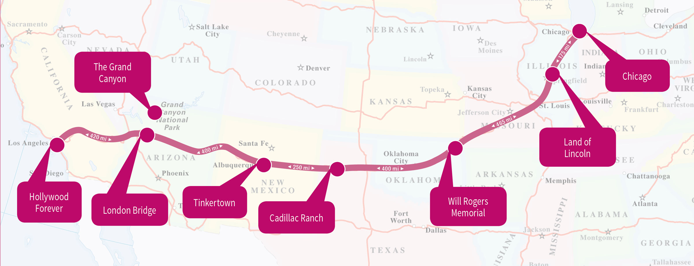
Driving Route 66 Through Missouri
Route 66 through Missouri was patched together from rutted roads, farm to market routes, and Osage Indian migratory paths.
In 1803, the Louisiana Purchase opened Missouri to western settlement and the Lewis and Clark expedition, which started here, symbolized the entrance to the New Frontier. Other seminal trails that originated here were the Overland, Oregon, and Santa Fe. Missouri also has a rich Civil War history. In 1858, the U.S. government installed telegraph lines along the Osage Indian trail and called it the “Old Wire Road.” This critical route was used for communication and the delivery of supplies during the Civil War and eventually paved the way for Route 66.
The path was laid, but the roads were made of wooden planks that quickly rotted and made travel a miserable experience. The first automobiles appeared in Missouri in 1891, and within 20 years there were more than 16,000 cars on its rickety roads. In 1920, the “Get Missouri Out of the Mud” campaign allocated $60 million to improve the roads. By 1931, the entire Route 66 stretch through Missouri was paved; it was the third state (preceded by Illinois and Kansas) along the Mother Road to turn to smooth asphalt.

During the Depression, federal funds were used to re-route Route 66 along major thruways in an effort to boost tourism and commerce. Even though Route 66 had become one of the busiest highways in the nation, the Federal government considered it obsolete because it didn’t meet the road building standards issued under the Federal-Aid Highway Act. Compared to the success of the Pennsylvania and New Jersey Turnpikes, Route 66 fell short. Denser concrete was added to handle the heavy traffic, but once I-44 was underway in 1956, Route 66 quickly became a distant memory. In fact, the original Route 66 signs between St. Louis and Joplin were removed as early as 1977, eight years before the official decommissioning of the road.
For approximately 300 miles, large segments of Route 66 remain intact through 11 Missouri counties. This road trip drives over lush rolling hills and past roadside churches, quaint towns, and pristine farmland to historic landmarks restored with the help of the National Park Service Route 66 Corridor Program, including the Wagon Wheel Motel in Cuba and the Boots Motel in Carthage.
Planning Your Time
If you use your time wisely, you can make it across Missouri in two days—but there is a lot to do and see. Start the first day in St. Louis and head west about 216 miles to spend the night in Springfield, a drive of about 4-5 hours. The second day will eventually see you cross three states off your Route 66 bucket list as you exit through Missouri through Joplin, zip along the 13-mile stretch in Kansas, and end in Tulsa, Oklahoma.
Driving Considerations
In Missouri, Route 66 was re-routed more times than in any other state. After the Depression, Springfield, Joplin, and Rolla added alternate routes, but the most convoluted changes were in the St. Louis area, where Route 66 branches off into six different roadways west of the Mississippi River.
If you’re pressed for time, I-44 offers an alternate option for speedy transport between towns. It’s best to drive this portion of Route 66 during the spring or the fall, since winter roads can be icy and the summers can be muggy. Although you’ll be driving through the some remote areas of the Ozarks, there are several towns with gas stations en route, so keep the tank at least half-full and you’ll be fine.