North Carolina Road Trips: The State’s Best Scenic Drives
Here are four great drives to experience the natural beauty of North Carolina.

Down East on U.S. 70
U.S. 70 runs almost the entire length of North Carolina, from Asheville to Core Sound. The farthest-east section, a dogleg through Craven, Jones, and Carteret Counties, gives you a taste of life Down East. This is a great drive to take if you’re staying in New Bern because you can pick up U.S. 70 there. Drive southeast through the Croatan National Forest, then east through seafood central—Morehead City. When you cross the bridge into the colonial port of Beaufort, leave U.S. 70 for a few blocks by turning right onto a side street. This takes you into historic downtown Beaufort and down to the waterfront along Front Street, where most of the attractions and 18th-century architecture are found.
From Beaufort, U.S. 70 winds up along Core Sound through fishing communities and marshes full of herons and egrets. Just past Stacy, you can either backtrack on U.S. 70 or proceed to the Cedar Island National Wildlife Refuge at the end of the peninsula and catch the Ocracoke Ferry at Cedar Island.
This drive is just over 70 miles. Driving quickly, it could be done in about 1.5 hours. But the point is to dawdle and enjoy the scenery and small towns, so it’s more fun to set aside a whole day. It’s an attractive drive any time of year, but old coastal cities like New Bern and Beaufort are most gorgeous in spring, especially late March and early April when the azaleas are in bloom.
Cherohala Skyway
On the opposite end of the state, the Cherohala Skyway was built for beauty. For 43 miles between Robbinsville and the town of Tellico Plains, Tennessee, the road winds along the top of the Smoky Mountains, sometimes at elevations well over 5,000 feet. The vistas are incredible, and the road is legendary for motorcyclists and pleasure trippers. Avoid the route in wintry weather, and fill your gas tank and stomach before leaving; there are no facilities other than restrooms along the way. You’ll feel like you’re in the wilderness on top of the world.
The prettiest times for this drive are summer and fall, but the road is often extremely crowded during leaf season. The Cherohala Skyway website lists current road conditions.
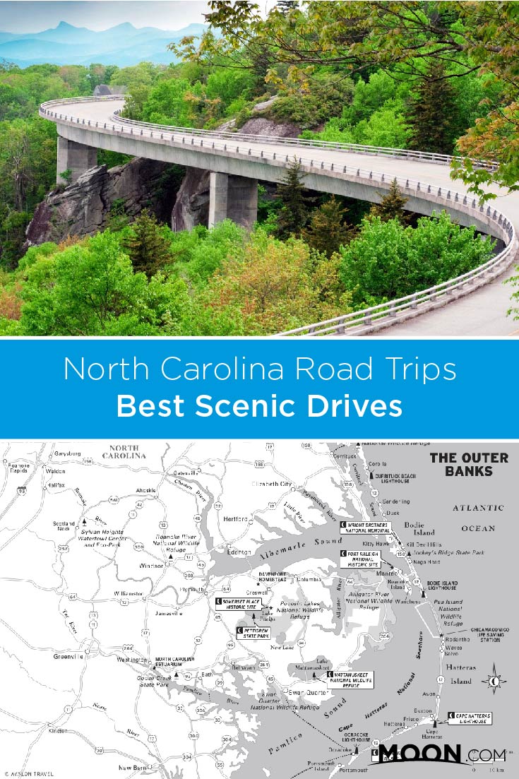
Blue Ridge Parkway
Running more than 450 miles between Shenandoah National Park in Virginia and Great Smoky Mountains National Park in North Carolina, the Blue Ridge Parkway is the mother of all scenic roads. It covers more than 200 miles in North Carolina, from Lowgap at the state line to Cherokee in the Smokies, and passes by many major destinations in western North Carolina, including Linville Falls, Mount Mitchell, and the Biltmore Estate. There are great places to stay on and near the parkway.
Traveling the parkway from the North Carolina line to Great Smoky Mountains National Park in one day requires a pretty rigorous schedule. Plan at least two days to enjoy sights along the way. Traffic on the parkway is always slow—the maximum speed limit never exceeds 45 mph, and along many stretches driving that fast would be reckless. Traffic can be congested in summer, particularly on weekends, and during leaf season. In any season, drive slowly and be ready to hit the brakes. The twisty road can get incredibly foggy, and you never know when a deer or other beast will leap out of the trees.
Sections of the parkway sometimes close due to weather or other conditions. Snow and ice are considerations three seasons of the year; rockslides are also possible. To find out about current closures, visit the National Parks Service website or call 828/298-0398.
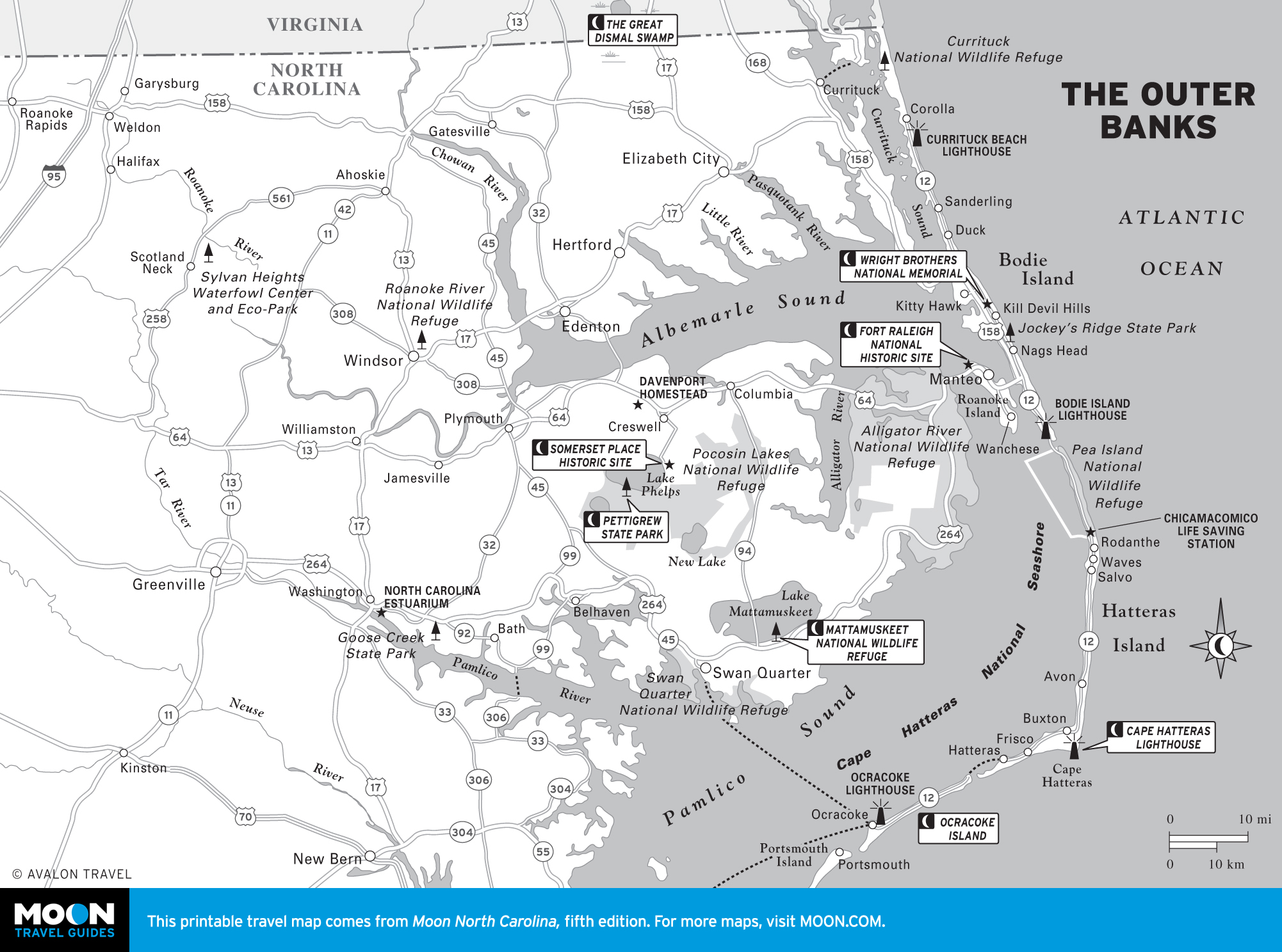
Highway 12: A Serene Seascape
Highway 12 traces the Outer Banks from the mainland onto the barrier islands and all the way up to the Virginia border. It’s a 160-mile trip that shows you nearly every square inch of the Banks.
Start at Sealevel (technically on U.S. 70, but a great place to start a beachside drive) and connect with Highway 12. Take the ferry at Cedar Island across to Ocracoke, home to one of the state’s oldest lighthouses, and the place where the pirate Blackbeard held an epic party before losing his head, literally, in a nearby inlet. Continue through scenery that’s surreally beautiful and serene. Another ferry takes you to the village of Hatteras at the southern end of Hatteras Island, part of the Cape Hatteras National Seashore. This landscape is desolate and beautiful, although you’ll find tiny villages along with a legion of surfers and kite-surfers. Crossing Oregon Inlet, you’re approaching the touristed section of the Outer Banks and stellar options for food and lodging. You’ll travel from Whalebone Junction into Nags Head and the dunes of Jockey’s Ridge, then on to Kill Devil Hills, where the Wright Brothers took their first flight, and the towns of Duck and Corolla, where the paved highway ends. If you’re adventurous and have a four-wheel-drive vehicle and beach driving experience, head north a few miles toward the Virginia border. A herd of wild horses (and not much else) lives here.
Related Travel Guide
Pin For Later