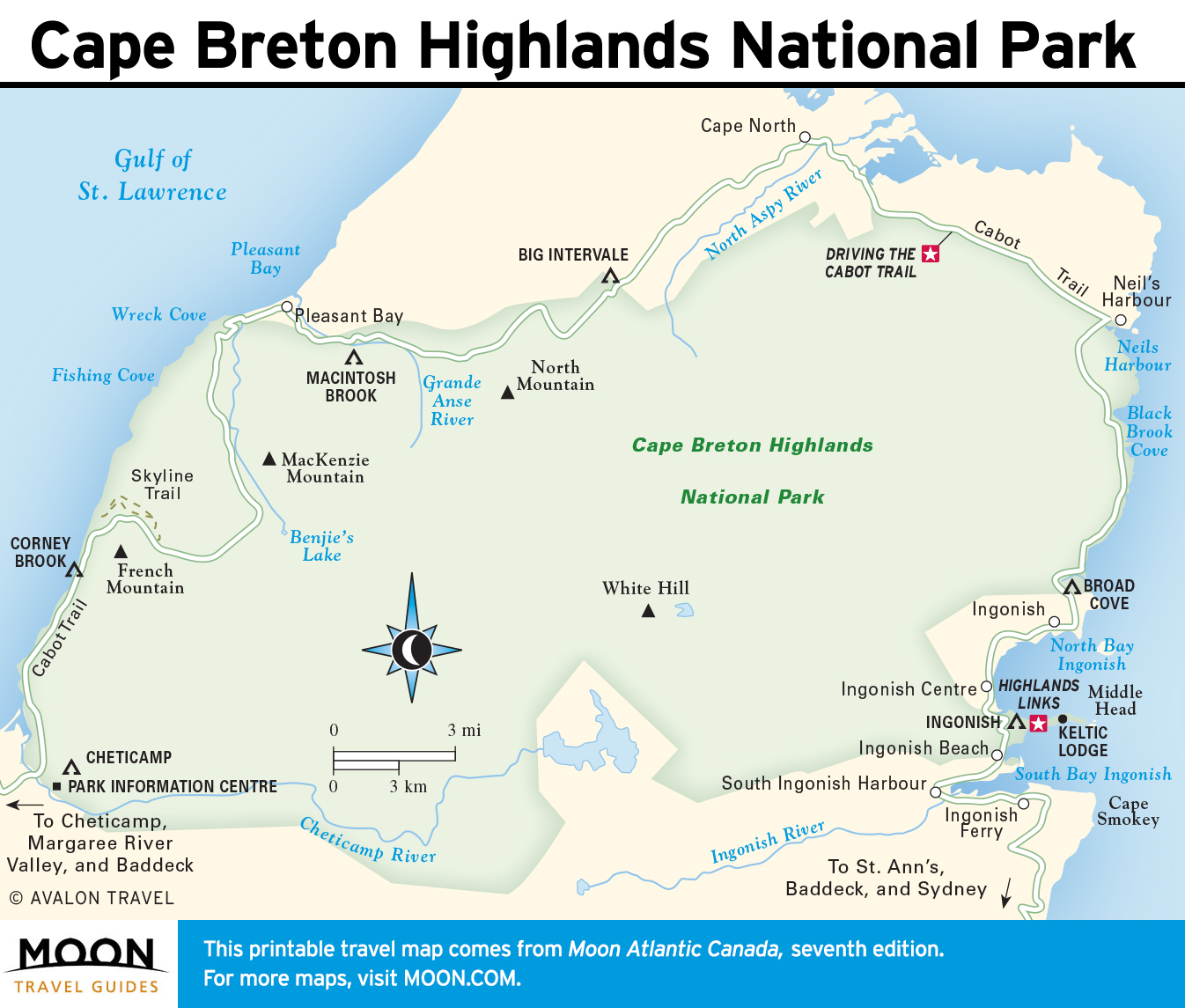
The Cabot Trail in Cape Breton Highlands National Park
Protecting a swath of wilderness at the northern tip of Cape Breton Island, this national park is one of the finest in Canada. While outdoor enthusiasts are attracted by opportunities to hike and bike, anyone can enjoy the most spectacular scenery simply by driving the Cabot Trail, which spans the length of the park from Chéticamp in the west to Ingonish in the east.
Heath bogs, a dry rocky plateau, and a high taiga 400 meters above sea level mark the interior of the 950-square-kilometer park. Rugged cliffs characterize the seacoast on the west side, where the mountains kneel into the Gulf of St. Lawrence, and gentler but still wildly beautiful shores define the eastern side. Nova Scotia’s highest point, 532-meter White Hill, is simply a windswept hump, far from the nearest road and with no formal access trail reaching it.
Typical Acadian forest, a combination of hardwoods and conifers, carpets much of the region. Wild orchids bloom under the shade of thick spruce, balsam fir, and paper birch. The Grand Anse River gorge near MacKenzie Mountain is the Acadian forest’s showpiece. Its terrain—with sugar maples, yellow birches, and rare alpine-arctic plants—has been designated an international biological preserve. The park is also a wildlife sanctuary for white-tailed deer, black bears, beavers, lynx, mink, red foxes, snowshoe hare, and more than 200 bird species, including eagles and red-tailed hawks.
Cape Breton Highlands National Park is open year-round, though campgrounds and the two information centers operate only mid-May-October. A National Parks Day Pass (adult $7.80, senior $6.80, child $3.90, maximum of $19.60 per vehicle) is is valid until 4pm the day after its purchase. Passes can be bought at both park information centers, Chéticamp and Ingonish campgrounds, or at the two park gates.
Driving the Cabot Trail in Cape Breton Highlands National Park
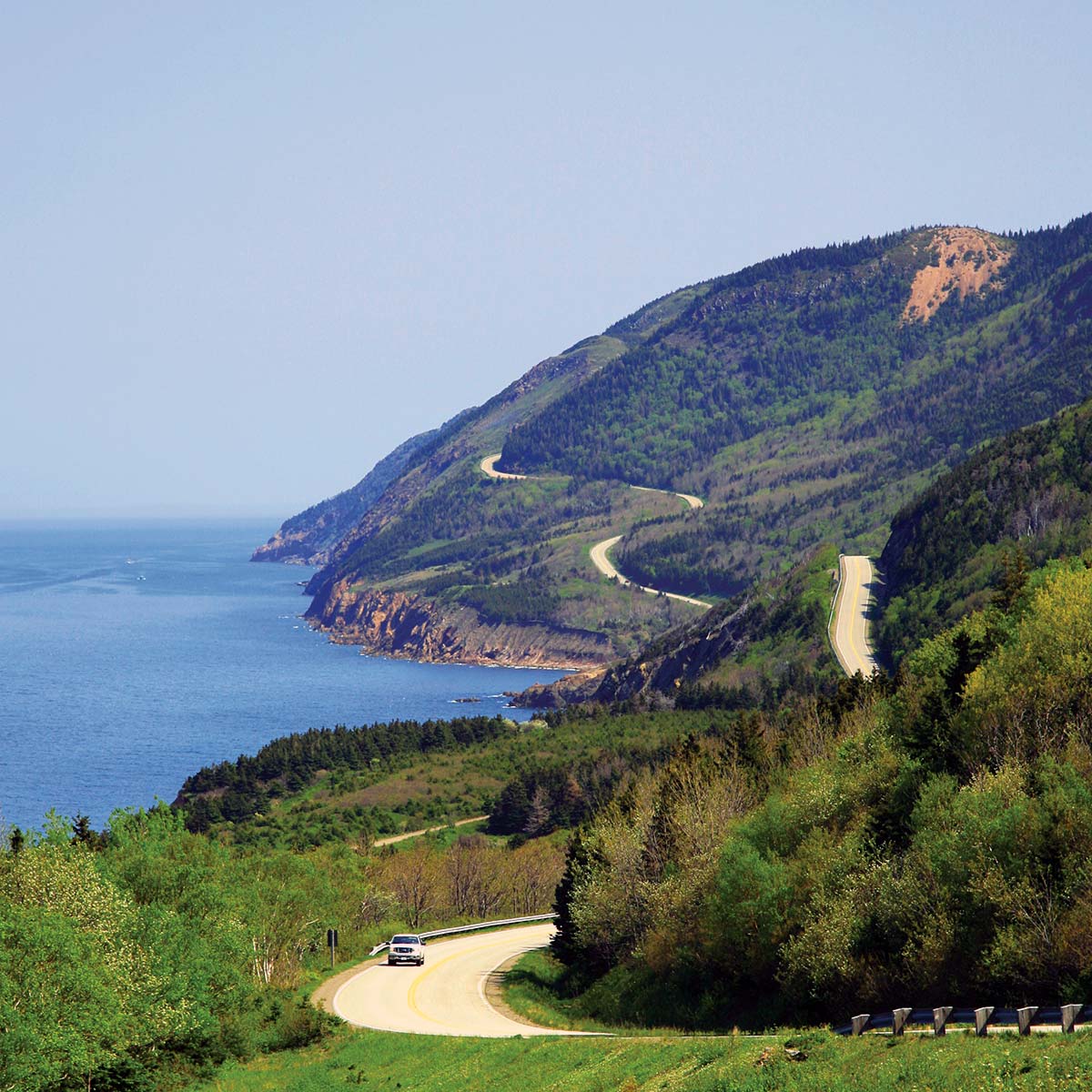
The Cabot Trail extends well beyond park boundaries along its 311-kilometer length, but the most spectacular stretch is undoubtedly the 110 kilometers through the park between Chéticamp and Ingonish. By allowing a full day for the drive, you will have time to walk a trail or two, stop at the best lookouts, and even head out on a whale-watching trip. This section describes the drive itself, with recreational opportunities discussed next. You can of course follow the Cabot Trail in either direction, but I’ve laid out the drive from Chéticamp to Ingonish (clockwise), meaning you pass the main park information center at the beginning of the drive and that you’re driving on the safer inland side of the road the entire way.
Thousands of outdoor enthusiasts tackle the Cabot Trail under pedal power each summer. The trip is not particularly long, but it is very strenuous in sections, and lack of a wide shoulder can make for some hair-raising moments.
Hiking is a major attraction for visitors of all fitness levels. The park offers 26 established hiking trails, varying from simple strolls shorter than half a kilometer to challenging treks leading to campgrounds more than 20 kilometers away. Many of the trails are level; a few climb to awesome viewpoints. Some hug the rocky shoreline; others explore river valleys. No matter what your abilities may be, you’ll be able to enjoy the park at your own speed. For details on hiking in the park, browse the many books sold at Les Amis du Plein Air, the bookstore within the Cheticamp Visitor Centre.
Chéticamp to Pleasant Bay
Make your first stop inside the park at the Cheticamp Visitor Centre (902/224-2306; mid-May-June and Sept.-Oct. daily 9am-5pm, July-Aug. daily 8:30am-7pm). Pick up a map, ask about hiking opportunities, browse the natural history displays, and hit the highway. You can pay for park entry here or at the tollgate a little farther up the road.
This is the most impressive stretch of one of the world’s most spectacular drives, with the highway clinging to the shoreline and then climbing steeply along oceanfront cliffs to a viewpoint 18 kilometers north of the information center.
Hiking
On the light side, the self-guiding Le Buttereau Trail leads 1.9 kilometers to wildflowers and good bird-watching opportunities. The trailhead is just north of the park gate north of Chéticamp.
Serious backpackers gravitate to the Fishing Cove Trail (16 km round-trip), a rugged journey to a campground and beach. You can reach the end of the trail in two hours, but allow at least three for the strenuous return trip back up to the highway.
Whale-Watching
From Pleasant Bay, one of two whale-watching spots in Nova Scotia (the other is the Bay of Fundy), a number of operators depart daily through summer. The region boasts a high success rate when it comes to spotting pilot, humpback, and minke whales, simply because of the high numbers close to the coastline. Captain Mark’s (902/224-1316 or 888/754-5112) is easily recognized down at the harbor by his booth shaped like a lighthouse. This company offers the option of stable ex-fishing boats (adult $45, senior $40, child $20) and rigid-hulled Zodiacs (adult $55, senior $50, child $30). The advantage with the latter is that the whales are reached much more quickly. You should book by phone in advance for July and August sailings.
Continuing Around the Cape
From Pleasant Bay, the park’s northwestern corner, the highway turns inland and wraps upward to 455-meter-high French Mountain. From this point, a level stretch barrels across a narrow ridge overlooking deeply scooped valleys. The road climbs again, this time to MacKenzie Mountain, at 372 meters, and then switchbacks down a 10-12 percent grade. Another ascent, to North Mountain, formed more than a billion years ago, peaks at 445 meters on a three-kilometer summit. The lookout opens up views of a deep gorge and the North Aspy River.
Hiking
For fit and energetic visitors, the seven-kilometer (two hours one-way) Skyline Loop climbs a headland, from which the lucky can spot pilot whales; along the way, look for bald eagles, deer, and bears. The trail begins where the Cabot Trail heads inland at French Mountain.
On overcast or wet days, the much easier Benjie’s Lake Trail provides an ideal break from driving. From a trailhead six kilometers east of the start of the Skyline Loop Trail, this easy walk takes about 30 minutes each way.
Cape North and Vicinity
The northernmost point on the Cabot Trail is Cape North, the name of a small service town (as well as a geographical feature to the north). Here a spur road leads 22 kilometers north to Meat Cove. Although outside the park, this road traverses complete wilderness before reaching the open ocean at St. Lawrence Bay. En route, Cabot’s Landing Provincial Park, the supposed landing site of English explorer John Cabot, offers a sandy beach on Aspy Bay (good for clam digging) and a picnic area, and marks the starting point for hikes up 442-meter-high Sugar Loaf Mountain.
The East Coast to Ingonish
From Cape North, it’s 45 kilometers east and then south to the resort town of Ingonish. Aside from tucking into a seafood feast at Neil’s Harbour, you should make time for a stop at Black Brook Cove. Backed by a short stretch of beach, the cove is an extremely popular spot for picnicking and swimming. To escape the summertime crowd, walk to the north end of the beach and follow the Jack Pine Loop through open coastal forest.