Maui

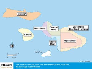
These free, printable travel maps of Maui are divided into seven regions:
Explore Maui with these printable travel maps. Ensure you have the newest travel maps from Moon by ordering the most recent edition of our travel guides to Hawaii.
Travel Maps of Maui


West Maui
West Maui pulses with a unique coastal vibe. The historic town of Lahaina was once the capital of the Hawaiian kingdom, and it retains a port town atmosphere. Warm weather and mostly dry conditions make this region a spectacular place for outdoor adventure.


Central Maui
Central Maui is the island’s population center and the seat of county government. Most visitors blow through town en route to their beachfront resort, but Central Maui has its own set of sights off the regularly worn trail.


South Maui
From the celebrity-laden resorts of Wailea to the condo-dwelling snowbirds of Kihei, South Maui is all about worshipping the sun and enjoying the procession of beaches.


Upcountry Maui
Rural, laid-back, and refreshingly cool, Upcountry is Maui’s most underrated zone. In Upcountry, you can watch the dramatic sunrise from the frosty peak of towering Haleakala, the sacred volcano from which the demigod Maui famously snared the sun.
East Maui: the Road to Hana
Along the famous, twisting Road to Hana, tumbling waterfalls and rugged hiking trails await.


Lana‘i
Home to 3,300 residents and two large resorts, this island is a playground of outdoor adventure.
Moloka‘i
Taking time to explore this island offers a chance to experience the roots of native Hawaiian culture.


