Virginia
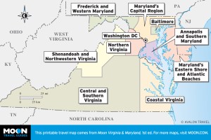
 These free, printable travel maps of Virginia are divided into five regions:
- Northern Virginia
- Coastal Virginia
- Shenandoah and Northwestern Virginia
- Central and Southern Virginia
Explore Virginia with these helpful travel maps. Ensure you have the newest travel maps from Moon by ordering the most recent edition of our travel guides.
Northern Virginia
From the busy halls of the Pentagon in Arlington and the trendy streets of historic old Town Alexandria to the quaint alleyways of Middleburg, Northern Virginia is a cornucopia of culture, history, business, outdoor recreation, culinary delights, and shopping.


Coastal Virginia
Visiting Coastal Virginia is a great way to take a break from everyday stresses and learn about history or relax on the beach. The region offers port towns, battleships, and beautiful clean beaches all within a short drive of one another.


Shenandoah and Northwestern Virginia
Shenandoah National Park and Northwestern Virginia are a very special part of the Blue Ridge Mountains. Stunning vistas, rivers, and streams traverse the area and loosely connect the towns that sit on the park’s doorstep.


Central and Southern Virginia
Sprawling Central and Southern Virginia offer some of the most beautiful countryside in America. Awesome mountain vistas, rolling foothills, and enchanting fall foliage can be found in this region, especially along the Blue Ridge Parkway. The state capital, Richmond, and historic Fredericksburg, Charlottesville, and Roanoke are key destinations in this vast region.


