Visit Grand Staircase-Escalante National Monument
Grand Staircase-Escalante National Monument spans a spectacular stretch of nearly 2 million acres across the Colorado Plateau. It would take a literal lifetime to explore in full. From red rock cliffs and the Escalante River to coniferous forests, you can hike, go canyoneering, or backpack your way through geologic, palaeontologic, and Indigenous history.
Far more expansive and less developed than any of the other regions covered in this guide, Grand Staircase-Escalante is for explorers at heart. While there are some easy well-marked trails, there are many more cairn-marked hikes, slot canyons, and long dusty drives requiring a map, compass, or GPS unit and desert resilience. The monument’s rugged nature makes it a great way to experience the wonders of southern Utah without the crowds you’ll find at many of its national parks.
Bigger than the state of Delaware, this national monument takes half its name from the series of sedimentary rock layers stepping up from the Grand Canyon to Bryce. Including the Pink Cliffs, White Cliffs, and Vermilion Cliffs, this massive geologic formation can only really be appreciated in its entirety from above. The other part of the monument’s name comes from the Escalante River, which honors Silvestre Vélez de Escalante, a Franciscan missionary who led a 1776 expedition in the area.
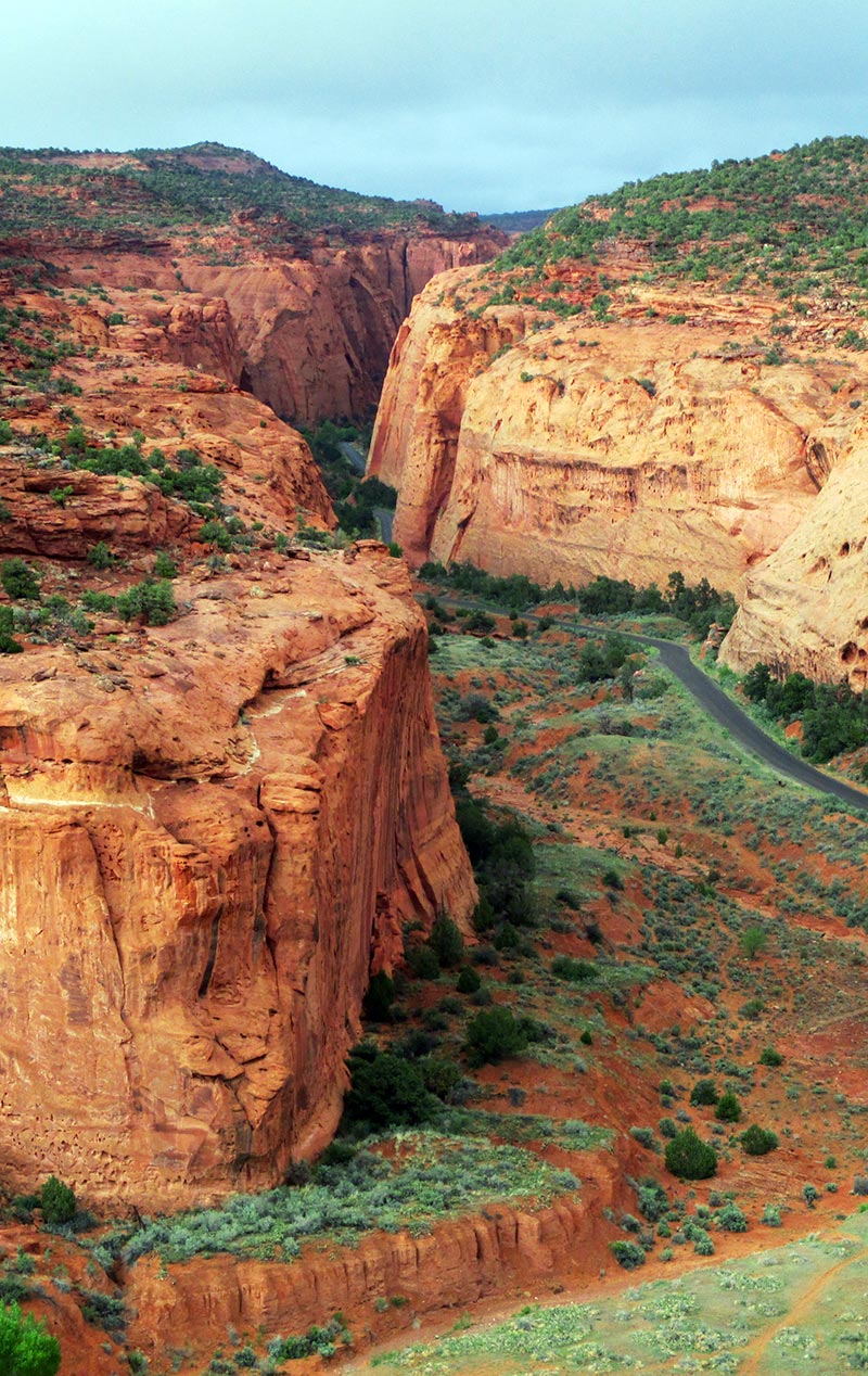
While the area is filled with prehistoric villages, mesas, and arches, the canyons may be the biggest draw. The river and its tributaries cut deep winding slot canyons through massive slickrock formations. The ultimate experience for many hikers is a multiday trek through these canyons. Day hikes and scenic drives on long backcountry roads are also great ways to experience this monument.
Backcountry drivers and long-distance cyclists will find mile after mile of desert and canyon to explore. Grosvenor Arch, with double windows, is a popular back-road destination. At the southern edge of the park, along the Arizona border, another rugged canyon system attracts many experienced long-distance hikers—the Paria River Canyon is even more remote than the Escalante.
Newsletter Signup
By clicking ‘Sign Up,’ I acknowledge that I have read and agree to Hachette Book Group’s Privacy Policy and Terms of Use
Orientation
Grand Staircase-Escalante National Monument stretches across a massive chunk of southern Utah, bordered by Arizona to the south, the town of Kanab and Bryce Canyon National Park to the west, Capitol Reef National Park to the northeast, and Glen Canyon National Recreation Area to the east. If you’re driving across the state from Zion and Bryce to Arches, Canyonlands, and Moab (or vice versa), the most direct route takes you through or alongside Grand Staircase-Escalante.
Three sweeping sections make up this national monument, from west to east: Grand Staircase, Kaiparowits Basin, and the Escalante canyons. The Grand Staircase is a series of cliffs and benches declining in elevation southward all the way to the Grand Canyon—hence the name “staircase.” From the bottom up, the chocolate cliffs, vermilion cliffs, white cliffs, gray cliffs, and pink cliffs each form distinct rock formations. The lower the cliffs, the more ancient the rock: The chocolate cliffs are the oldest part of the Staircase, formed as long as 250 million years ago, while the Pink Cliffs are the youngest, developed a mere 60 million years ago.
Plateaus and mesas stretch across some 1,650 square miles (4,273 sq km) of the Kaiparowits Basin in the center of the national monument. Devoid of dramatic cliffs or canyons, there is arguably less going on in this part of Grand Staircase-Escalante. One of the main backcountry roads that runs through the basin is Smoky Mountain Road.
The second namesake of this national monument, the Escalante canyons are a series of canyons carved by the Escalante River and its tributaries, stretching from Boulder Mountain down to Lake Powell and the Glen Canyon area. These narrow, steep, and twisting Navajo sandstone canyons provide endless exploration, from backpacking and day hiking to rafting and canyoneering.
Many of the national monument’s best- known hikes and sights are off Highway 12. The most noteworthy towns in the area are Escalante and Boulder, both on Highway 12 along the monument’s northern edge, and Kanab, near its southwestern border. The other main highway is U.S. 89, which passes through the southern part of Grand Staircase- Escalante. Throughout the monument’s nearly 2 million acres are a number of rugged back-country drives—some connecting Highway 12 with U.S. 89, some straight-up thrilling, and some just roads to glorious nowhere.
Planning Your Time
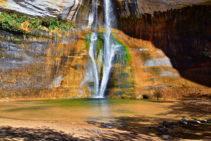
If you only have one day, plan to drive stunning Highway 12. Lower Calf Creek Falls Trail begins right off the highway between Escalante and Boulder, and hiking it is a great way to spend half a day.
If you have an additional day or two, base yourself either in Escalante (with convenient camping and moderately priced accommodations) or in Boulder (where it’s possible to sleep and eat in luxury). Spend your second day exploring Hole-in-the-Rock Road, where you can hike slot canyons in the Dry Fork of Coyote Gulch and explore Devils Garden. You could easily spend several days in this part of the monument, either backpacking along the Escalante River or exploring its various canyons as day hikes. If you’re up for backpacking, it’s only a one-nighter to hike from the town of Escalante along the river to the Highway 12 bridge.
If you have more time, head south from Cannonville to the Kanab area on Cottonwood Canyon Road (be sure to check road conditions before heading out). Stop and walk up through the Cottonwood Narrows, and at the north end of the road, visit Grosvenor Arch and Kodachrome Basin State Park. If you want to make a loop drive, return on the Johnson Canyon and Skutumpah Roads, with a hike along Lick Wash.
Exploring the Park
There is no entrance fee to visit Grand Staircase-Escalante National Monument (435/644-1200). Free permits are required for all overnight backcountry camping or backpacking. There are fees to camp in the monument’s three developed campgrounds.
Some areas within the monument require day-use fees or overnight permits—a couple
of which are highly sought after. Hikers in the Paria Wilderness area—which includes Paria Canyon, Coyote Buttes, and the Wave—are required to buy a permit (day hikers $6 per day, overnight $5 per day), as are hikers at the Calf Creek Recreation Area (day-use $5 per vehicle).
It’s best to have a travel strategy when visiting this huge national monument. Also important, especially for longer visits: a vehicle that can tackle rugged roads. A Subaru will be adequate in dry weather, but when the clay is wet and muddy, the back roads are virtually impassable to all but 4WD vehicles with high clearance.
Only two paved roads pass through the monument areas, both running east-west. To the north, beautiful Highway 12 links Bryce Canyon and Capitol Reef National Parks, with access to the Escalante River canyons. Car and Driver magazine has rated this route one of the 10 most scenic in the country, with countless vistas and geologic curiosities. Incredible scenery also awaits on U.S. 89, which runs along the southern edge of the monument between Kanab and Lake Powell. It’s also the access road for the North Rim of the Grand Canyon.
Three fair-weather dirt roads, each with a network of side roads and trails, cut through the rugged heart of the monument, linking the two paved roads. Before heading out on these back roads, check with the visitor center for conditions; high-clearance vehicles are recommended.

Newsletter Signup
By clicking ‘Sign Up,’ I acknowledge that I have read and agree to Hachette Book Group’s Privacy Policy and Terms of Use
Pin It for Later
