Visiting Pictured Rocks National Lakeshore in Michigan
With waterfalls, sand dunes, a lighthouse, great hiking, and more, Pictured Rocks National Lakeshore has something for everyone. Lake Superior takes center stage at this National Park Service property, just 3 miles (4.8 km) wide but spanning more than 40 miles (64 km) along the shore of the magnificent lake, from Munising to Grand Marais.
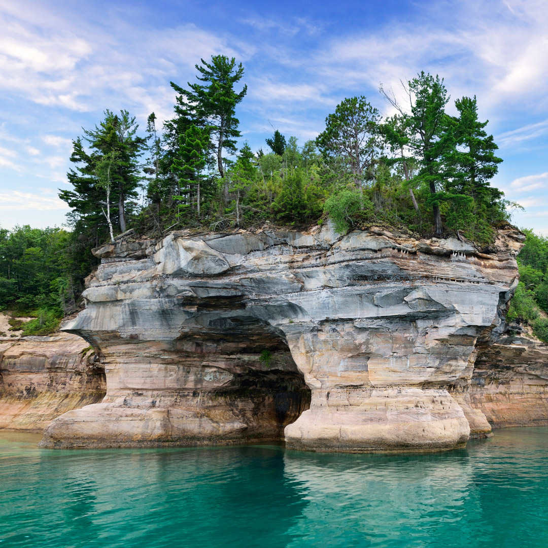
Pictured Rocks derives its name from the sandstone bluffs that rise 200 feet directly from the water’s surface. Washed in shades of pink, red, and green due to the mineral‐rich water that seeps from the rock, these famous bluffs extend for more than 15 miles (24 km), at times sculpted into caves, arches, and castle‐like turrets. The national lakeshore also features a lesser‐known but equally spectacular stretch of shoreline called the Grand Sable Banks, where 200‐foot‐high sand dunes are hemmed by a 12‐mile (19‐km) ribbon of sand and pebble beach. You’ll also find lakes, forest trails, waterfalls, a lighthouse, and other historical attractions—plenty of reasons to put Pictured Rocks at the top of the list for anyone visiting the eastern UP.
Newsletter Signup
By clicking ‘Sign Up,’ I acknowledge that I have read and agree to Hachette Book Group’s Privacy Policy and Terms of Use
Sights in Pictured Rocks National Lakeshore
Munising Falls Area
Just inside the park’s western boundary, a short trail leads to 50‐foot Munising Falls, which spills into a narrow gorge before emptying into Lake Superior’s Munising Bay. The highlight of this spot used to be the trail that led hikers behind the falls, but erosion problems prompted its closure. It’s still worth a stop, though, for the falls and the adjacent interpretive center, which offers a glimpse of this peaceful area’s history, home to a belching pig‐iron furnace in the 1860s. Munising Falls also marks the west trailhead for the Lakeshore Trail, a 43‐mile (69‐km) segment of the North Country National Scenic Trail, which spans seven states from New York to North Dakota. The Lakeshore Trail runs the length of the Pictured Rocks National Lakeshore—and, predictably, is never far from the water’s edge. The park’s eastern trailhead lies near Sable Falls.
Past Munising Falls, the paved access road ends at Sand Point, site of the national lakeshore headquarters. While the headquarters primarily houses offices and not visitor services, it also displays some interesting Coast Guard and shipwreck artifacts on its grounds. Sand Point has a small beach and a boat ramp, a good spot to launch a small craft for exploring nearby Grand Island.
Miners Castle
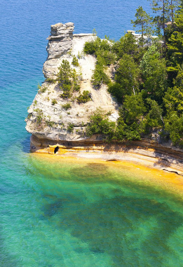
The sandstone cliffs 5 miles (8 km) northeast of Munising Falls are known as Miners Castle, for the turret‐like shape caused by wind and wave erosion. The nine‐story‐high rock formation is impressive and ranks as one of the park’s most popular attractions, despite a 2006 collapse of one of the signature turrets. Boardwalks and steps lead to two viewing platforms out on the rock, where you can peer down into the crystalline waters of Lake Superior. If that moves you to do a little beachcombing and wading, a nearby trail leads down some steps through the pines to Miners Beach.
To reach Miners Castle, follow County Road H‐58 east from Munising to the well-marked turnoff for Miners Castle Road. Before you reach the Miners Castle formation itself, you’ll see another sign on Miners Castle Road directing you to Miners Falls. It’s a 1‐mile (1.6‐km) walk to this pleasant cascade, where Miners Creek tumbles 40 feet over a rocky escarpment.

Chapel Basin Area
Continuing northeast on County Road H‐58, the next auto‐accessible route into the heart of the park is at Melstrand, where the gravel and dirt Chapel Road bumps 6 miles (10 km) toward the shore and another park highlight, the Chapel Basin area. Park here and find plenty to entertain you for a day or a weekend: three waterfalls, a deep inland lake, Lake Superior beaches, and a good hiking loop.
Chapel Falls is the key attraction, as evidenced by the wide paved pathway that leads 1.5 miles (2.4 km) to the falls. Amid a pale birch forest, frothing water drops like a horsetail some 90 feet into a gorge and onto Chapel Lake. Continue past the falls to reach Chapel Beach in another 1.8 miles (2.9 km), where you’ll find a backcountry campground. From here, you can turn right to Chapel Rock and follow the Lakeshore Trail 1.5 miles (2.4 km) to Spray Falls, one of the least visited and loveliest waterfalls in the park, where Spray Creek drops over the sandstone cliffs right into Lake Superior.
If you turn left instead of right at Chapel Beach, you can make a 10-mile (16-km) loop around Chapel Basin. Along the way, you’ll pass Grand Portal Point—another significant Pictured Rocks landmark—before returning to the parking area. Don’t leave Chapel Basin without a visit to Mosquito Falls, a little farther inland off Chapel Road. The Mosquito River spills over a series of ledges, creating an accessible waterfall that’s calm enough for wading and soaking fatigued feet. A trail leads to various sections of the falls and links up with the Lakeshore Trail.
Beaver Lake
Near the center of the park, 800‐acre Beaver Lake is the largest inland lake in Pictured Rocks. Anglers are drawn to the lake and the tributaries that feed it, especially for trout. Little Beaver Lake, connected by a small channel, has a boat launch. Boats are limited to 10 horsepower or less, making this a pleasant waterway for paddlers. Little Beaver has one of the park’s three auto‐accessible campgrounds, with eight sites available on a first‐come, first‐served basis. Be aware that wetlands cover much of the land between Beaver Lake and Lake Superior, so insects can be a problem, especially in June and early July.
Two good hiking trails leave from the campground. The short and pleasant 0.7‐mile (1.3‐km) White Pine Trail is a self‐guided nature trail that circles through a 300-year‐old pine forest. The 5‐mile (8‐km) Beaver Basin Loop Trail makes a lap around Little Beaver and Big Beaver Lakes, then follows the Lake Superior shore past sea caves cut by the lake’s pounding waves. Boardwalks skirt the wetlands before returning to the trailhead.
Twelvemile Beach
An icon near the Twelvemile Beach campground says it all: Indicating that this is a permitted beach area, it shows a swimmer not in the usual “crawl” position, but with water lapping at the ankles. In other words, the water here is extremely cold. Swim if you dare, but wading is more realistic.
This is what keeps Twelvemile Beach the pristine ribbon of sand that it is. The colder waters keep away all but the most enthusiastic lovers of nature, making it a place where you can stroll for hours with only the company of peregrine falcons, bald eagles, and deer wandering down for a drink. You may even see the occasional black bear snorting around in the sand.
The Twelvemile Beach campground is easy to reach, just a short drive off County Road H‐58 through a pretty birch forest. Many of the 37 campsites string out along a bluff over the beach—come midweek, or early on Saturday, which is often a turnover day, for one of the choice spots. Some are larger than the average suburban lot and undoubtedly have a better view. Well‐placed stairs deposit campers and picnickers at lake level. The campground also has a nice day‐use area at its east end.
Five miles (8 km) farther up the beach (or County Rd. H‐58) lies the auto‐accessible Hurricane River campground, where the Hurricane River spills into Lake Superior.
Au Sable Point
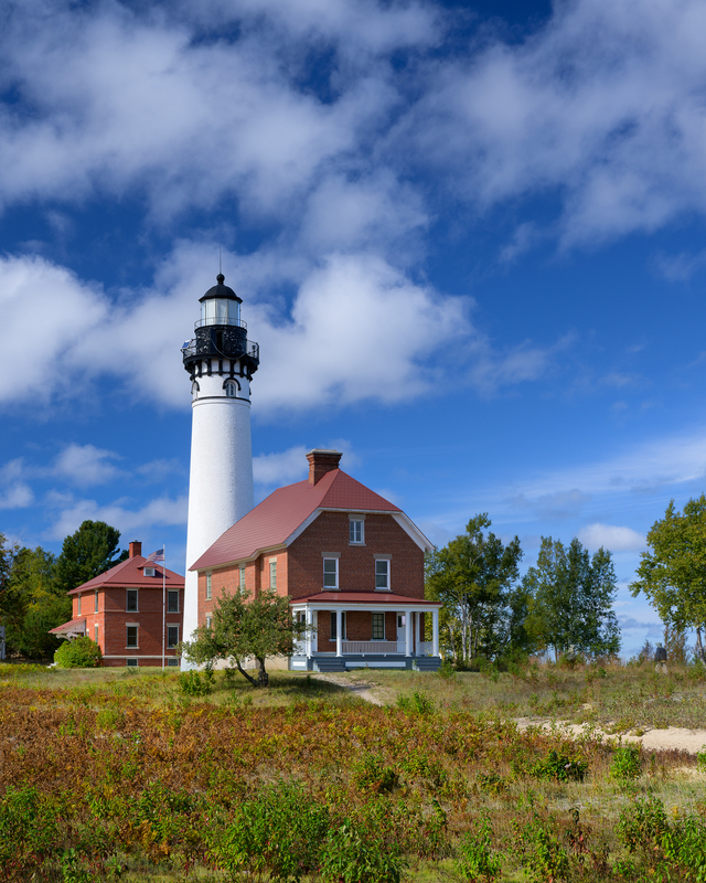
It’s a 1.5‐mile (2.4‐km) walk along the Lakeshore Trail from the Hurricane River campground to the Au Sable Light Station at Au Sable Point. Built in 1874, the 87‐foot brick lighthouse and its keepers provided decades of reliable service—warning ships away from the rocky shoals that extend out for nearly a mile and create shallows of just 6 to 30 feet. Nonetheless, at least 10 steamers were wrecked here. As you walk the trail from the campground, look for parts of the shipwrecks just offshore, often poking out of the sand bottom and easily visible in the gin‐clear water. The light was automated in 1958 and recently restored.
Grand Sable Dunes
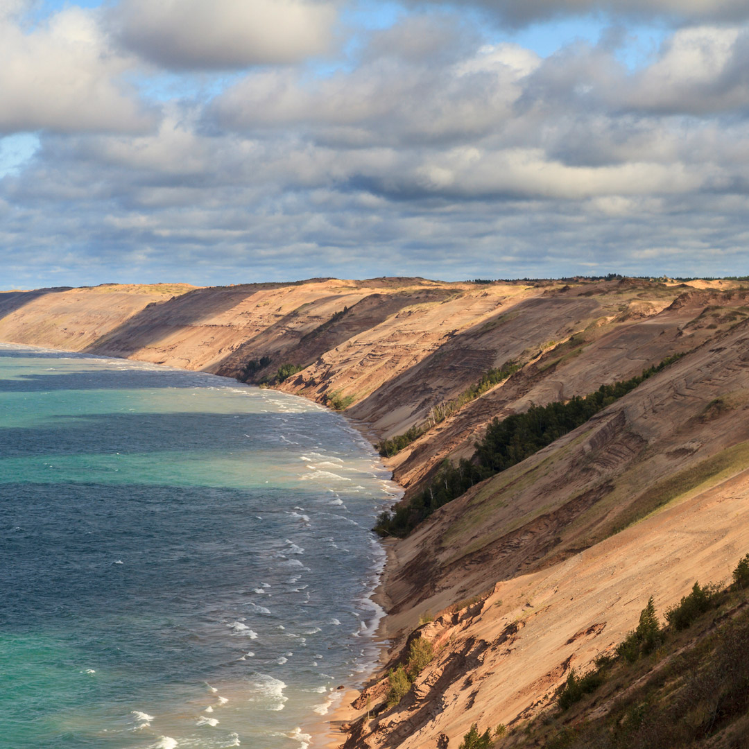
Just east of Au Sable Point, the Log Slide Overlook marks the spot of a once busy logging operation. In the late 1800s, loggers used this high point—some 300 feet above Lake Superior—to send freshly cut logs down to the water’s edge, where they were loaded on Great Lakes schooners. Today, you can stand on a platform and simply marvel at the view, with the lighthouse to your left, the great dunes to your right, and the brilliant blue of the big lake filling the horizon. If you’re in the mood for some exercise, the 2‐mile (3.2‐km) stretch of the North Country National Scenic Trail from the Log Slide to the Au Sable Light Station is one of the park’s most scenic hikes.
The Grand Sable Banks and Dunes (grand sable is French for “big sands”) stretch for nearly 5 miles (8 km) from the overlook, glacial banks of gravel supporting the huge mounds of sand. They are magnificent when viewed from a distance—glowing gold and rising up abruptly from the cobalt waters of Lake Superior. In many areas, especially near the overlook, the dunes are free of grasses and plants, so you can frolic around on them without fear of damaging fragile plant life or causing erosion. Though park officials discourage it for safety reasons, no one will stop you from sliding down the slope. Be aware, though, that the climb back up takes much longer than the way down.
Most people choose to explore the dunes from the eastern end. Near the Grand Sable Visitors Center, a trail winds across the top of the dunes, where fragile marram grass, beach pea, and sand cherry cling to the sand (be careful to stay on the trail here). Interpretive signs discuss the plants’ tenuous hold on the environment. The trail to Sable Falls also leaves from the visitors center, a 0.5‐mile (0.8‐km) walk largely composed of steps. As you work your way downhill, you’ll be treated to several views of this exceptionally picturesque cascade, which drops in tiers through a narrow canyon and out to a rocky Lake Superior beach. Across County Road H‐58, the sandy shores and often warm waters of Grand Sable Lake make this a wonderful spot for a swim or a picnic.
Newsletter Signup
By clicking ‘Sign Up,’ I acknowledge that I have read and agree to Hachette Book Group’s Privacy Policy and Terms of Use
Pin For Later
