Driving and Hiking along the Cabot Trail
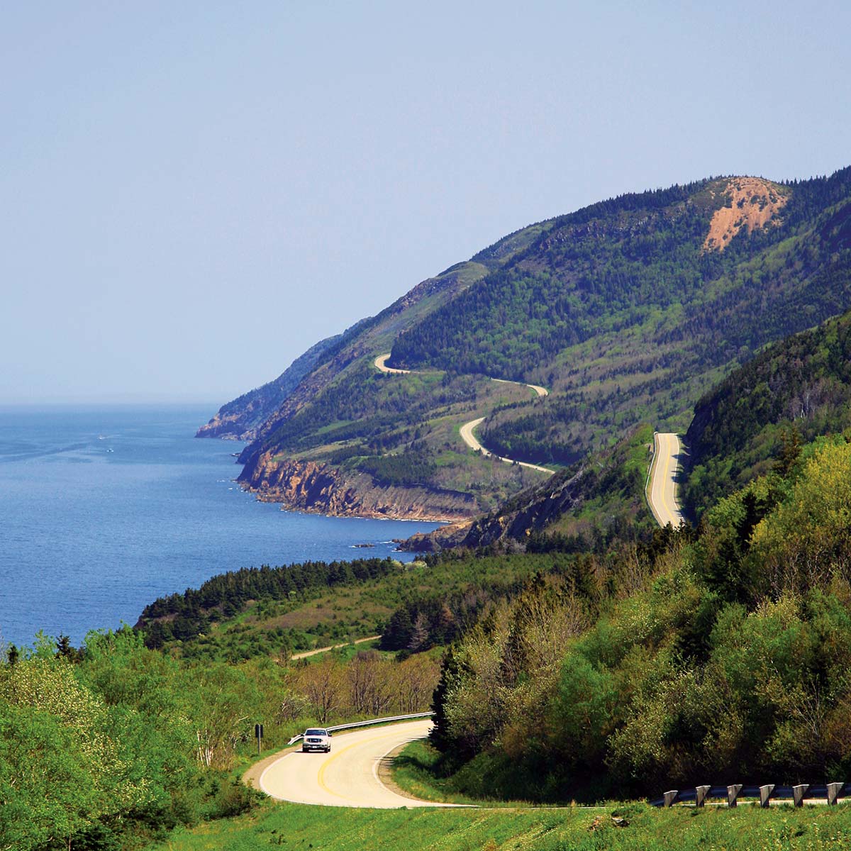
The Cabot Trail extends well beyond Cape Breton Highlands National Park boundaries along its 311-km (190-mi) length, but the most spectacular stretch is undoubtedly the 110 km (68 mi) through the national park between Chéticamp and Ingonish. By allowing a full day for the drive, you will have time to walk a trail or two, stop at the best lookouts, and even head out on a whale-watching trip. This section describes the drive itself, with hiking opportunities discussed next. You can of course follow the Cabot Trail in either direction, but I’ve laid out the drive from Chéticamp to Ingonish (clockwise), meaning you pass the main park information center at the beginning of the drive and you’re driving on the safer inland side of the road the entire way.
Thousands of outdoor enthusiasts tackle the Cabot Trail under pedal power each summer. The trip is not particularly long, but it is very strenuous in sections, and lack of a wide shoulder can make for some hair-raising moments.

Chéticamp to Pleasant Bay
Make your first stop inside Cape Breton Highlands National Park at the Chéticamp Visitor Centre (902/224-2306, mid-May-mid-Oct. daily 8:30am-5pm). Pick up a map, ask about hiking opportunities, browse the natural history displays, and hit the highway. You can pay for park entry here or at the tollgate a little farther up the road.
This is the most impressive stretch of one of the world’s most spectacular drives, with the highway clinging to the shoreline and then climbing steeply along oceanfront cliffs to a viewpoint 18 km (11.2 mi) north of the visitor center. After the Corney Brook Campground, the highway turns inland and wraps upward to 455-m-high (1,493-ft-high) French Mountain. From this point, a level stretch barrels across a narrow ridge overlooking deeply scooped valleys. The road climbs again, this time to MacKenzie Mountain, at 372 m (1,220 ft), and then switchbacks down a 10-12 percent grade.
Waters off Pleasant Bay are one of two whale-watching spots in Nova Scotia (the other is the Bay of Fundy), and a number of operators depart daily through summer. The region boasts a high success rate when it comes to spotting pilot, humpback, and minke whales, simply because of the high numbers close to the coastline. Captain Mark’s (126 Harbour Rd., 902/224-1316) is easily recognized down at the harbor by his booth shaped like a lighthouse. This company offers 2- to 2.5-hour tours in rigid-hulled Zodiacs (adult $75, senior $70, child $60), which have the advantage of reaching the whales more quickly than a traditional boat.
Pleasant Bay to Cape North
From Pleasant Bay, the park’s northwestern corner, the highway ascends to North Mountain, formed more than a billion years ago, peaking at 445 m (1,460 ft) on a 3-km (1.9-mi) summit. The lookout opens up views of a deep gorge and the North Aspy River.
Cape North and Vicinity
The northernmost point on the Cabot Trail is Cape North, the name of a small service town (as well as a geographical feature to the north). Here a spur road leads 22 km (13.7 mi) north to Meat Cove. Although outside the park, this road traverses complete wilderness before reaching the open ocean at St. Lawrence Bay. En route, Cabot’s Landing Provincial Park, the supposed landing site of English explorer John Cabot, offers a sandy beach on Aspy Bay (good for clam digging) and a picnic area, and marks the starting point for hikes up 442-m-high (1,450-ft-high) Sugar Loaf Mountain.
The East Coast to Ingonish
From Cape North, it’s 45 km (28 miles) east and then south to the resort town of Ingonish. Aside from tucking into a seafood feast at Neil’s Harbour, you should make time for a stop at Black Brook Cove. Backed by a short stretch of beach, the cove is an extremely popular spot for picnicking and swimming. To escape the summertime crowd, walk to the north end of the beach and follow the Jack Pine Trail through open coastal forest.
Hiking
While driving the Cabot Trail through Cape Breton Highlands National Park is one of Atlantic Canada’s best-known attractions, hiking in the national park is also a major draw for visitors of all fitness levels. Most trails are easy to moderate and can be completed in a half-day or less.
The park offers 26 established hiking trails, varying from simple strolls shorter than half a kilometer (0.3 mi) to challenging treks leading to campgrounds more than 20 km (12.4 mi) away. Many of the trails are level; a few climb to awesome viewpoints. Some hug the rocky shoreline; others explore river valleys. No matter what your abilities may be, you’ll be able to enjoy the park at your own speed. For details on hiking in the park, browse the many books sold at Les Amis du Plein Air, the bookstore within the Chéticamp Visitor Centre.
Here are my favorite Cape Breton Highlands trails, detailed in a clockwise direction starting from Chéticamp.
Le Buttereau Trail
First up north of the Chéticamp park entrance, this self-guided 1.6-km (1-mi) loop (allow 30 minutes) winds through the site of an Acadian settlement that has been reclaimed by nature and is now a wildflower-filled meadow. The trailhead is just north of the park gate north of Chéticamp.
Skyline Trail
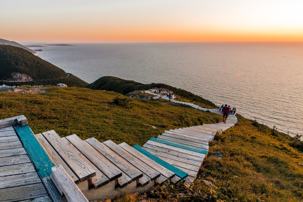
If you only have time for one hike, make it the Skyline Trail, which begins where the Cabot Trail heads inland at French Mountain. This easy trail, 3.3 km (2 mi) each way, is level most of the way before climbing to a headland with sweeping park and ocean views (with occasional whale sightings). On the trail itself, you may also see bald eagles, deer, moose, or bears. Extend the adventure by looping north from near the end of the trail to additional viewpoints. Allow two hours out and back to the lookout, or three hours for the 8.5-km (5.3-mi) loop.

Benjie’s Lake Trail
On overcast or wet days, this trail provides an ideal break from driving. From a trailhead 6 km (3.7 mi) east of the start of the Skyline Trail, this easy 1.6-km (1-mi) each way walk takes about one hour round-trip. At trail end is a forest-enclosed lake where moose are often sighted.
Fishing Cove Trail
Serious hikers gravitate to this rugged 16-km (9.9-mi) round-trip trek to a remote beach and grassed area. You can reach the end of the trail in two hours, but with an elevation gain of 355 m (1,165 ft), allow at least three hours for the strenuous return trip back up to the highway. The trailhead is just south of Pleasant Bay.
Mica Hill Trail
Continuing across the inland section of the park, Paquette Lake Road leads to the trailhead for the 4-km (2.5-mi) one-way Mica Hill Trail (allow 90 minutes each way). By the time you reach the end of the trail, you will have gained 300 m (980 ft) of elevation, but your effort is rewarded by 360-degree views of the barrens, the mountainous northern tip of the island, and distant coastal villages. The trail is named for the abundance of mica outcrops at the high point.
Jack Pine Trail
Most visitors stop at Black Brook Cove, south of Neil’s Harbour, to relax on the beach or take a dip in the ocean, but this day-use area is also the starting point for the Jack Pine Trail. Jack pine is more common farther south, but this pocket thrived after a fire swept through the region in 1921. The loop is 2.3 km (1.4 mi) and takes 30-40 minutes to complete. Along the trail is a lookout over the ocean, but it also connects to the Coastal Trail, which loops back to Black Brook Cove and a couple of bonus lookouts.
Related Travel Guide
- Strategic, flexible itineraries including scenic drives, ocean excursions, and the best of the Maritimes
- Top experiences and activities: Take in stunning scenery while driving the Cabot Trail or the Irish Loop, visit an active archeological dig at the Colony of Avalon, or study artifacts from the Titanic at the Maritime Museum of the Atlantic. Savor local oysters at a waterfront restaurant, sample seasonal beers at North America’s oldest operating brewery, and refuel with a hearty rappie pie after a day of touring Nova Scotia
- Best outdoor adventures: Bike through UNESCO-protected towns or cruise past massive icebergs. Cross-country ski and snowmobile in Sugarloaf Park or skate on frozen lakes near Halifax. Hike along rocky shoreline or through wildflower-filled river valleys. Kayak to a secluded island for a picnic lunch and camp out under the stars at oceanside parks
- Expert advice from Canadian author Andrew Hempstead on when to go, where to stay, and how to get around
- Full-color photos and detailed maps throughout
- Background information on the environment, culture, and history
- In-depth coverage of Nova Scotia, New Brunswick, Prince Edward Island, Newfoundland, and Labrador
Exploring more of Canada? Check out Moon Canadian Rockies or Moon Victoria & Vancouver Island.
About Moon Travel Guides: Moon was founded in 1973 to empower independent, active, and conscious travel. We prioritize local businesses, outdoor recreation, and traveling strategically and sustainably. Moon Travel Guides are written by local, expert authors with great stories to tell—and they can’t wait to share their favorite places with you.
For more inspiration, follow @moonguides on social media.
Newsletter Signup
By clicking ‘Sign Up,’ I acknowledge that I have read and agree to Hachette Book Group’s Privacy Policy and Terms of Use
Pin It for Later


