Hiking Multnomah Falls
Enjoy a dense forest and plenty of waterfalls along the Wahkeena Falls-Multnomah Falls Loop, including one of Oregon’s tallest waterfalls.
Distance: 5.9 miles (9.5 km) round-trip
Duration: 3 hours
Elevation Gain: 1,670 feet (510 m)
Effort: Moderate
Trail: Dirt trail, paved path, stream crossings, rocks, gravel
Users: Hikers, leashed dogs
Season: Year-round, but trail may be icy or snowy winter-early spring
Passes/Fees: None
Maps: USGS topographic map for Multnomah Falls, OR-WA; free trail maps available at the U.S. Forest Service information center inside Multnomah Falls Lodge
Trailhead: Multnomah Falls parking area (accessed from I-84)
Facilities: Flush toilets and drinking water at Multnomah Falls Lodge
Contact: Columbia River Gorge National Scenic Area; 541/308-1700
Newsletter Signup
By clicking ‘Sign Up,’ I acknowledge that I have read and agree to Hachette Book Group’s Privacy Policy and Terms of Use
Start the Hike
Plan to share portions of this trail with scores of fellow hikers; consider saving this hike for a weekday if possible, or start before 9am.
Mile 0-0.8: Multnomah Falls Lodge to Wahkeena Falls
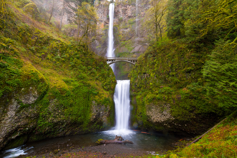
From the parking lot, follow the pedestrian crosswalk south under I-84, crossing Multnomah Creek and the Historic Columbia River Highway, to the plaza in front of Multnomah Falls Lodge, which has a snack stand and restrooms; you can also grab a free trail map inside. Pause to appreciate views of Multnomah Falls from here now or at the end of the hike. From the lodge head west to begin the counterclockwise loop along the shoulder of the Historic Columbia River Highway. After 0.1 mi (160 m), take a slight left onto the Return Trail. This mostly flat dirt and gravel path parallels the highway and connects the parking areas at Multnomah and Wahkeena Falls (so you could start the hike from either end—but there’s more parking at this trailhead). After 0.5 mi (0.8 km), you’ll descend a short series of stone steps before coming to a junction; turn left to head west on the unnamed paved path. You’ll shortly see a sign for Wahkeena Falls; proceed up the paved path, ascending through a forest of Douglas fir and hemlock. In 0.2 mi (0.3 km), you’ll emerge at the base of the upper tier of Wahkeena Falls, which cascades more than 240 ft (73 m) total and gets its name from the Yakama Nation’s word for “most beautiful.”
Mile 0.8-1.4: Wahkeena Falls to Lemmons Viewpoint
The paved path switchbacks steeply uphill beyond the falls, arriving in 0.6 mi (1 km) at a junction; turn right for a short spur trail to Lemmons Viewpoint, named for a firefighter who died nearby; it offers unfettered views of the Columbia River Gorge, including Beacon Rock and Hamilton Mountain to the east.
Mile 1.4-1.7: Lemmons Viewpoint to Fairy Falls
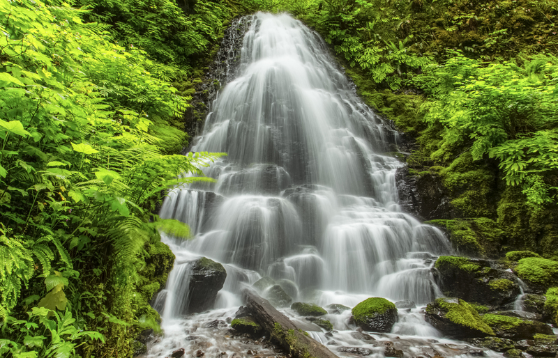
Back at the junction, head south on the Wahkeena Trail, a dirt path that parallels Wahkeena Creek through a lush canyon before arriving, in 0.3 mi (0.5 km), at the base of Fairy Falls. Good news: This marks the end of the hardest part of the ascent, and the trail levels out from here. A wooden plank has been laid across the creek at the base of the waterfall; cross and keep an eye out for ice in winter and spring.
Mile 1.7-2.6: Fairy Falls to Boulder Intersection
A 0.1-mi (160-m) amble past Fairy Falls brings you to a junction; ignore the Vista Point Trail to the left and instead head right to remain on the Wahkeena Trail. You’ll begin to spot burned-out tree trunks—by-products of the 2017 Eagle Creek Fire—with increasing frequency along here, but wildflowers including purple phlox, bear grass, and dandelions bloom in spring and summer along this stretch. In 0.4 mi (0.6 km) is an intersection with the Angel’s Rest Trail, but head left to remain on the Wahkeena Trail. In 0.4 mi (0.6 km) you’ll arrive at another junction; again ignore the Vista Point Trail to the left and continue straight ahead on the Wahkeena Trail. This intersection is also a pleasant spot for a snack break, with its several boulders for sitting.
Mile 2.6-3.5: Boulder Intersection to Larch Mountain Trail
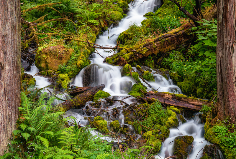
Soon after you’ll hit yet another junction, with the Devil’s Rest Trail; veer left to remain on the Wahkeena Trail. Shortly you’ll come upon the first of several minor stream crossings, and then enter an area heavily damaged by the Eagle Creek Fire; every tree along this stretch is burned and barren, but plenty of undergrowth remains, including vine maple and ferns, as well as a variety of wildflowers in spring and early summer, such as purple foxglove, yellow tiger lilies, and purple fireweed. After 0.9 mi (1.4 km), you’ll come to another stream crossing as you descend the canyon alongside Multnomah Creek. Shortly after, you’ll turn left onto the Larch Mountain Trail, following a sign for the Multnomah Falls Lodge and heading north, parallel to Multnomah Creek. Cross the last stream, and then watch your step as you continue along the trail, which gets especially rocky along here.
Mile 3.5-4: Larch Mountain Trail to Wiesendanger Falls
After 0.25 mi (0.4 km), you’ll pass a pair of waterfalls in relatively quick succession: 55-ft (17-m) Ecola Falls, only partially visible from the trail, and Wiesendanger Falls, also cascading 55 ft (17 m) into a small gorge. You’ll get a better look at Wiesendanger Falls in another 0.2 mi (0.3 km) when the trail switchbacks to its base; where the waterfall enters the creek makes a popular swimming hole in summer.
Mile 4-4.7: Wiesendanger Falls to Multnomah Falls Viewpoint Spur
Another 0.1 mi (160 m) past Wiesendanger Falls you’ll pass Dutchman Falls, a series of three short waterfalls. In 0.3 mi (0.5 km), head left at the junction, following a sign for the Multnomah Falls Viewpoint. The 0.3-mi (0.5-km) round-trip spur ends at a plaza at the top of Multnomah Falls; while you don’t see much of the waterfall itself from here, it’s worth the short side trip for its views of the Columbia River Gorge.
Mile 4.7-5.9: Multnomah Falls Viewpoint Spur to Multnomah Falls Lodge
Back at the junction, turn left onto the Larch Mountain Trail, following the Multnomah Falls Lodge sign. You’ll ascend briefly before descending via 11 paved switchbacks, crossing Benson Bridge near the base of Multnomah Falls; the 635-ft (194-m) waterfall tumbles over basalt cliffs in two major steps and is among the most popular natural attractions in the Pacific Northwest, drawing more than two million visitors each year. After 1.2 mi (1.9 km), the trail levels out back at the Multnomah Falls Lodge.
Directions
From Portland, head east on I-84 for 28.3 mi (45.6 km). Take exit 31—off to the left—and follow the signs for Multnomah Falls to arrive in the parking area.
Note that, if parking in the large lot along I-84, a Multnomah Falls Timed Use Permit is required 9am-6pm daily Memorial Day-Labor Day. (A second parking area can be accessed along the Historic Columbia River Highway and does not require a permit.) Permits are available two weeks in advance; additional permits are also made available two days in advance, and a limited number of same-day permits are available at the Gateway to the Gorge Visitor Center and Cascade Locks Historical Museum. Note that having a permit does not guarantee parking, and both parking lots fill to capacity early on weekends; traffic along the Historic Columbia River Highway may also be backed up for miles along the way at times. Try to arrive during less-busy times (before 9am or after 4pm). Check for details and updates on the permit program at Oregon Department of Transportation.
Given the heavy traffic around Multnomah Falls, consider taking the Columbia Gorge Express, a shuttle between Portland and several popular destinations in the Gorge, including Multnomah Falls. The shuttle departs Portland at the Gateway Transit Center (9900 NE Multnomah St., Portland), and the ride takes 35-45 minutes. Buses operate year-round, but check the website for the schedule because it varies seasonally.
Another popular option for arriving at the trailhead without driving is the Sasquatch Shuttle. The pet-friendly service allows hop-on, hop-off access to Multnomah Falls.
Best Nearby Bites
Enjoy an upscale meal at Multnomah Falls Lodge. Located at the base of Multnomah Falls, its on-site restaurant offers fine Northwest-inspired cuisine.


Newsletter Signup
By clicking ‘Sign Up,’ I acknowledge that I have read and agree to Hachette Book Group’s Privacy Policy and Terms of Use
Pin It for Later
