The Best Hikes in Utah
Looking for the best hiking trails in Utah? Whether you’re looking for an easy day hike or a challenging multi-day trek, here are the best hikes in Utah for seeing canyons, waterfalls, and red rock formations.
The Zion Narrows (Bottom Up)
Distance: 9.4 miles (15.1 km) round-trip; Duration: 8 hours; Elevation gain: 200 feet (61 m); Effort: strenuous; Trailhead: end of Riverside Walk; Shuttle Stop: Temple of Sinawava
At the end of Zion National Park’s scenic drive, hike through the waters of the Virgin River up Zion Canyon as it reaches its narrowest point. The mystical lighting, sense of adventure required, and otherworldly hanging gardens lining the canyon walls make this hike worth the hype. While you’ll find hordes of other hikers at the mouth of the canyon, crowds thin quickly the farther you go. Early summer (mid-June-mid-July) and early autumn (mid-Sept.-mid-Oct.) are the best windows, and you’ll want to wear sturdy boots and bring poles for balance—you can rent this equipment in nearby Springdale. Check conditions before you go, as sometimes water levels are too high or cyanobacteria blooms make the water toxic.
Bryce Under-the-Rim Trail
Distance: 23 miles (37 km) one-way; Duration: 2 days or longer for the full hike; Elevation gain: 1,500 feet (457 m); Effort: strenuous; Trailheads: Bryce Point, Rainbow Point; Shuttle Stop: Bryce Point, Rainbow Point
This breathtaking tour of Bryce Canyon National Park winds 23 miles (37 km) from Bryce Point up to Rainbow Point, the park’s highest point. Located in Bryce’s wilderness, this trail is far quieter and more serene than others in the park. The trail takes you through stunning hoodoo scenery, canyons, and ponderosa groves. Day hikers can hike up as far as they want, then turn around for an out-and-back journey; several connecting trails also make it easy to exit the trail at different points and take the shuttle back to Bryce Point. Backpackers can camp at one of seven designated campsites and hop on the park shuttle back down.
Delicate Arch Trail
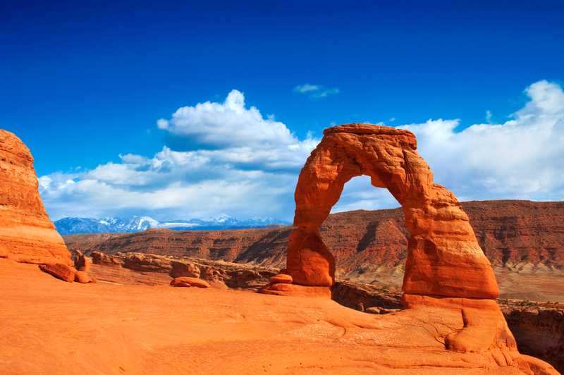
Distance: 3 miles (4.8 km) round-trip; Duration: 2 hours; Elevation gain: 500 feet (152 m); Effort: moderate-strenuous; Trailhead: Wolfe Ranch
Crowded for good reason, the hike to the base of the iconic Delicate Arch is one of the highlights of a visit to Arches National Park. After about 20-30 minutes of easy, uneventful hiking, the trail transitions to steep slickrock and the views open up across the park to the La Sal Mountains in the distance. Just before the end of the trail, walk up to the small, decidedly indelicate Frame Arch for a picture-perfect view of the final destination. Standing at the base of Delicate Arch is a magical moment: The arch rises out of the barren, almost lunar rock face, at the edge of a sandstone amphitheater overlooking the Colorado River valley. Do this hike at dawn or dusk for minimal crowds and the best light.
Newsletter Signup
By clicking ‘Sign Up,’ I acknowledge that I have read and agree to Hachette Book Group’s Privacy Policy and Terms of Use
Lower Calf Creek Trail
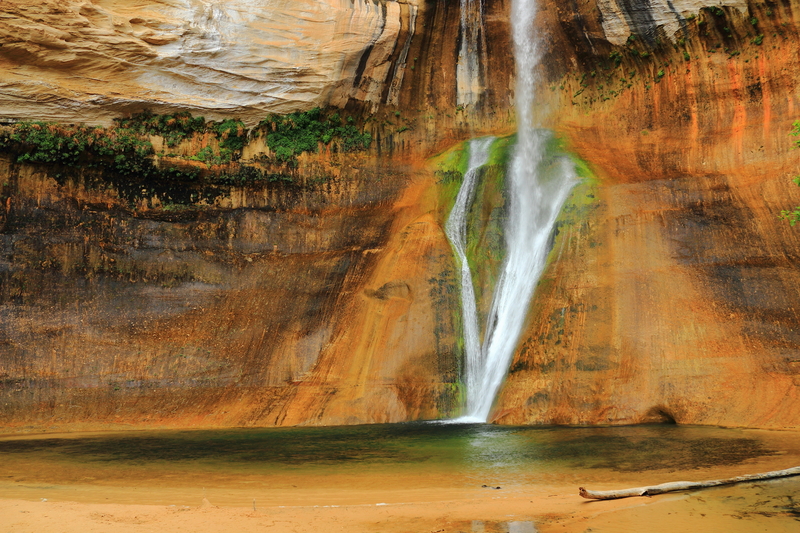
Distance: 6 miles (9.6 km) round-trip; Duration: 4 hours; Elevation gain: 250 feet (76 m); Effort: easy-moderate; Trailhead: Calf Creek Campground (day-use $5), 16 miles (26 km) east of Escalante on Hwy. 12
In Grand Staircase-Escalante National Monument, the Escalante River defines much of the landscape, and Calf Creek is one of its many tributaries. This out-and-back trail follows the creek through peaceful desert terrain and past a dramatic alcove to a stunning waterfall. The trailhead sits right off the highway, so it’s one of the more accessible adventures in Grand Staircase-Escalante. From the parking area just off Highway 12, the trail winds between high Navajo sandstone cliffs streaked with desert varnish, where you’ll see beaver ponds, a petroglyph of three figures holding hands, and ultimately, the misty 126-foot-high (38-m) Lower Calf Creek Falls.
Aspen Grove Trail to Mount Timpanogos
Distance: 16.6 miles (26.6 km) round-trip; Duration: 8-10 hours; Elevation gain: 4,900 feet (1,494 m); Effort: strenuous; Passes/Fees: $10 to park; Trailhead: Theater in the Pines Picnic Area
Just past Sundance Resort along the Alpine Scenic Loop, this is one of two trails leading to the 11,753-feet (3,582-m) summit of Mount Timpanogos, the second-highest peak in the Wasatch Range. This is a beautiful, challenging trek that leads past multiple waterfalls, wildflower fields, and vibrant lakes, with mountain goats frequently sighted along the way. Oddly, the first mile or so of the trail is paved. Once you reach the first waterfall, continue about 5 miles (8 km) to see Emerald Lake. The Summit Trail branches off west of Emerald Lake, climbs a steep slope, and follows a jagged ridge to the top. Hiking season is mid-July-mid-October. In winter and spring, Timpanogos is covered in snow, requiring specialized equipment to summit. On heavy snow years, snowfields can linger all summer, and hikers will want Yaktrax and poles—check local trail reports before you go.
Brighton Lakes Trail
Distance: 6 miles (9.6 km) round-trip; Duration: 3 hours; Elevation gain: 1,673 feet (510 m); Effort: moderate; Passes/Fees: $10 to access road to trailhead; Trailhead: Silver Lake Loop trailhead
Winding through gorgeous alpine lake country in Big Cottonwood Canyon just outside Salt Lake City, this trail begins behind Brighton Lodge. Silver Lake has a boardwalk, giving full access to fishing docks. The trail crosses wildflower-filled meadows, then climbs to Brighton Overlook, 1 mile (1.6 km) from the start. Dog Lake, surrounded by old mine dumps, lies 200 yards (183 m) to the south. Continue on the main trail 0.5 mile (0.8 km) to large and deep Lake Mary, below Mount Millicent. Lake Martha is another 0.5 mile (0.8 km) up the trail, and Lake Catherine just 1 mile (1.6 km) farther. Total elevation gain for the 3-mile (4.8-km) hike to Lake Catherine is 1,200 feet (366 m). Hikers can also go another 0.5 mile (0.8 km) to Catherine Pass and descend 1.5 miles (2.4 km) to Albion Basin in Little Cottonwood Canyon. Sunset Peak (10,648 ft/3,246 m) can be climbed by following a 0.5-mile (0.8-km) trail from the pass.
Newsletter Signup
By clicking ‘Sign Up,’ I acknowledge that I have read and agree to Hachette Book Group’s Privacy Policy and Terms of Use
Pin It for Later
